
The University of Tulsa
Mountain Cedar Pollen Forecast
Metropolitan Area |
Exposure Risk |
|
Dallas/Fort Worth |
Moderate |
|
Austin |
High |
|
San Antonio |
High |
Date Issued: 22 January 2014
Mountain Cedar Location(s): Edwards Plateau, Texas
Regional Weather: Wednesday, January 22 TX/OK:
After a long run of sunny and warm conditions, the region will see a major change beginning today and into tomorrow.
Cold air from the northeast and the possibility of rain and freezing precipitation will occur over the forecast
period. Southern Oklahoma will start sunny today with high temperatures reaching the mid-50s. It will be clear
mostly clear but very cold with northeast winds. Lows tonight will be in the teens in central Oklahoma and low
20s in the border region with Texas. To the south across Texas today will return to seasonal temperatures in the
60s. Skies will start the day as sunny and mostly sunny across the Edwards Plateau. Winds will be from the southwest
to begin the day but during the afternoon and early evening cold conditions from the northeast will move across
the area. Tonight temperatures will fall into the-mid 30s on the Edwards Plateau, and 40s in the surrounding communities.
To the north, along the I-35 corridor cold conditions will be heading south. This evening the low in Dallas/Ft.
Worth will be in the upper 20s. Overnight skies will go from partly cloudy this evening to mostly cloudy overnight.
Tomorrow partly cloudy conditions will occur across Oklahoma. Temperatures will be in the mid-20s for the high
in central Oklahoma and along the border it will not get above the low 30s. Winds will be from the northeast at
10 to 20 miles per hour. Across Texas temperatures will stay in the 30s across the Edwards Plateau and in the
low to mid 40s in the communities surrounding the plateau. Winds will be moderate to strong from the northeast.
There is a 30% chance of precipitation in the surrounding communities and on the Plateau itself, a 20% chance
of rain, maybe sleet and other forms of frozen precipitation, will occur. Skies will be cloudy during the day
and into the evening. Tomorrow night the chance of precipitation will remain but temperatures will drop into the
teens to low 20s resulting in frozen forms of precipitation overnight. Winds will remain from the north and northeast
at moderate to strong levels.
Trajectory weather: Air mass trajectories over the Edwards Plateau will begin the day under sunny and mostly
sunny skies with light to moderate winds from the south and southwest. Temperatures will be in the low to mid-60s
across the Edwards Plateau and upper 60s in the surrounding communities from San Antonio north along the I-35 corridor.
Conditions will cool towards the north with the Dallas/Ft. Worth metro area expected to be in the upper 50s.
Winds will be light from the south and southwest. Across the Edwards Plateau this afternoon, partly cloudy conditions
will build in as the leading edge of cold air from the northeast moves into the state. The trajectories will be
pushed upwards and appear to swirl around northern Texas as this occurs. The change will occur late afternoon
and into the evening with cloudy skies building in and temperatures dropping. Winds will establish themselves
from the northeast across the region by tomorrow morning. Tomorrow skies will be cloudy with a chance of precipitation
across Texas. Temperatures will struggle to get into the 40s at the warmest locations and winds will be strong
from the northeast. There is a 20% to 30% chance of light rain or even freezing rain in the coldest areas. Tomorrow
night will be very cold with lows in the teens and low twenties. The chance of rain, freezing rain and snow will
occur across the Edwards Plateau area including the surrounding communities.
OUTLOOK: *** High Threat Today and Low Threat Tomorrow
*** Conditions for pollen release today remains high with moderately warm temperatures in the upper 50s to
upper 60s across the Texas region. Winds today will be from the southwest and move trajectories to the northeast
until the push of cold northeast air is encountered. The air will lift the atmosphere as it moves in at ground
level causing the trajectories to gain elevation. Most of the interaction will occur in northern Texas region
from the Pan Handle eastward from the border region south to the Dallas/Ft. Worth region. Winds will be light
to moderate today. The changes coming with colder air from the east will begin this afternoon and tonight. Lows
tonight will drop into the upper 20s in Dallas and be in the mid-30s across the Edwards Plateau. Tomorrow highs
will not be much higher than tonights lows. Conditions will be good for pollen release, entrainment and travel.
However with the incursion of cold air tonight entrained pollen should remain essentially within the boundaries
of Texas. As colder conditions invade tonight the chance of pollination tomorrow looks to be significantly reduced.
The cold conditions should bring a pretty pollen free atmosphere across the region. However, indications are
that pollen remains ready to be released and entrained into the atmosphere once conditions warm again. High levels
continue to be recorded at reporting stations across the region.
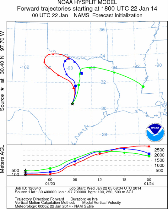
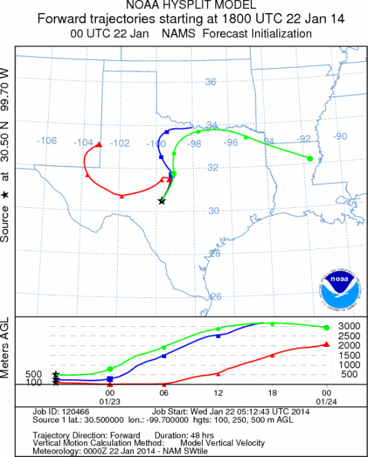
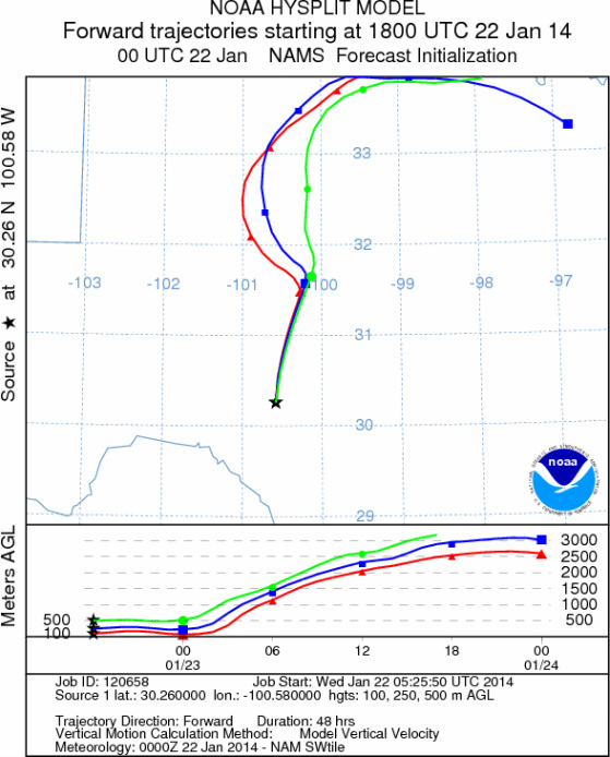
Trajectory Start (s) (shown by *
on map): Austin, TX; Junction, TX; Sonora, TX.
AUSTIN
JUNCTION
SONORA
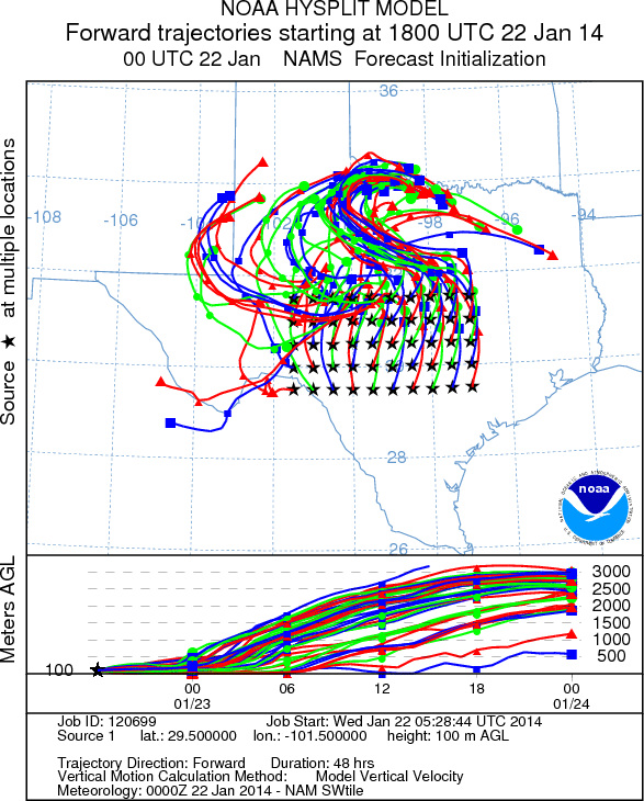
EDWARDS PLATEAU COMPOSITE
Prepared by: Estelle
Levetin (Faculty of Biological
Science, The
University of Tulsa, 800 S. Tucker Dr., Tulsa, OK 74104) and ) and Peter
K Van de Water (Department of Earth and Environmental Science, California State University Fresno,
2576 East San Ramon Avenue, M/S ST24, Fresno CA 93740-8039). This forecast gives the anticipated future track of
released Mountain Cedar pollen, weather conditions over the region and along the forecast pathway, and an estimated
time of arrival for various metropolitan areas.
Questions: Aerobiology Lab e-mail: pollen@utulsa.edu
Return to Forecasting Home Page