
The University of Tulsa
Mountain Cedar Pollen Forecast
Metropolitan Area |
Exposure Risk |
|
Dallas/Fort Worth |
Low |
|
Austin |
Low |
|
San Antonio |
Low |
Date Issued: 23 January 2014
Mountain Cedar Location(s): Edwards Plateau, Texas
Regional Weather: Thursday, January 23 TX/OK:
After a long run of sunny and warm conditions, the region will see a major change today and tomorrow with cold
air dropping southward. Cold air from the northeast and the possibility of rain and freezing precipitation will
occur over the forecast period. Southern Oklahoma will start the day partly cloudy with high temperatures only
reaching the mid-20s in Oklahoma City and the low 30s to the south near the Texas border. Across Texas it will
be cloudy with the high temperatures on the Edwards Plateau staying in the 30s. the surrounding communities will
warm slightly, but San Antonio will struggle to get to 50 degrees. Winds will be from the northeast and moderate
to strong. Most areas have a chance of seeing gusts in the 25 to 30 miles per hour range. There will also be
a 20% to 30% chance of rain and light rain initially then turning to sleet and snow. Overnight partly cloudy skies
will occur to the north of the Dallas/Ft Worth metro region into Oklahoma. Across the Edwards Plateau cloudy conditions
will persist as well in the surrounding communities. The strong northeasterly winds will continue and temperatures
will be very cold. In Oklahoma lows will be just above single digits. Across Texas tonight will be in the lower
20s and teens on the Plateau and in the upper 20s in the surrounding communities. The chance of light rain and
sleet will continue through the night into tomorrow. Tomorrow the winds will finally calm and begin to switch
to a southwesterly flow across the northern areas and to the west. Highs for the region will barely get into the
40s in Oklahoma and will be in the 30s across Texas. The chance of light rain and snow will remain at 20% to
30%. The Plateau will remain cloudy but in the surrounding communities mostly cloudy skies will occur and in southern
Oklahoma it will be mostly sunny. Tomorrow night mostly to partly cloudy skies will remain and temperatures will
fall into the mid to upper 20s across the region. Winds will be light from the west and southwest. Conditions
will begin to warm into the weekend.
Trajectory weather: Air mass trajectories over the Edwards Plateau will begin the day under cloudy conditions
with strong northeasterly winds pushing everything to the south. Temperatures will be in the low to mid to upper
30s except for the surrounding communities that will struggle into the 40s. San Antonio may just make it across
the 50 degree mark. There will be a chance of rain, light rain, sleet and snow across most of the Edwards Plateau.
Winds will be moderate to strong with gusts in many areas reaching 30 miles per hour. Tonight the chance of precipitation
will increase to 50% across the Plateau and in the edge communities in the form of sleet and snow. Temperatures
will be in the 20s and the dominant northeasterly flow will continue. Tomorrow, cold conditions will persist with
highs in the 30s in most areas. As the day develops the northerly flow will be replaced by westerly and southwesterly
winds to begin the warm-up. Winds will be light. Tomorrow night the skies begin to break-up with mostly to partly
cloudy conditions but temperatures fall into the mid-20s to upper 20s across the region.
OUTLOOK: *** Low Threat today and Low Threat Tomorrow *** Conditions for pollen
release today and tomorrow will be very poor. Temperatures will be in the upper 20s to 30s across the Texas and
southern Oklahoma region today. The warmest areas along the southern edge of the Edwards Plateau may see conditions
in the upper most 40s. There is a 20 to 30% chance of rain, light rain and sleet developing across the region,
Winds will be from the northeast at strong conditions with gusts up to 30 miles per hour or more as the cold air
moves out of the northeast across the region. The changes with colder air from the northeast will chill the region
and should restrict any pollen release today and well as tomorrow. High temperatures tomorrow are expected to
only rise into the upper 30s. By tomorrow afternoon, winds will begin to turn and by tomorrow evening a southwesterly
breeze and warmer conditions will begin to move in. Low temperatures tonight and tomorrow night are expected to
be in the teens to the north and twenties across Texas. With the colder conditions today, tonight, tomorrow and
tomorrow night along with the chance of precipitation during this period, pollination looks to be significantly
reduced. The cold conditions should bring a nearly pollen free atmosphere across the region.
Trajectory Start (s) (shown by *
on map): Austin, TX; Junction, TX; Sonora, TX.
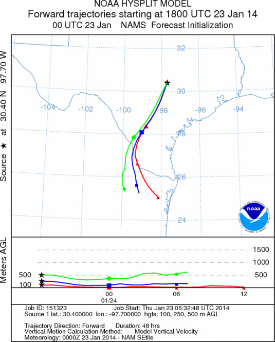
AUSTIN
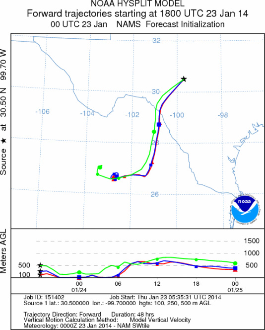
JUNCTION
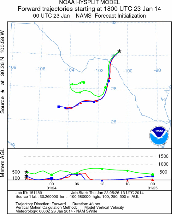
SONORA
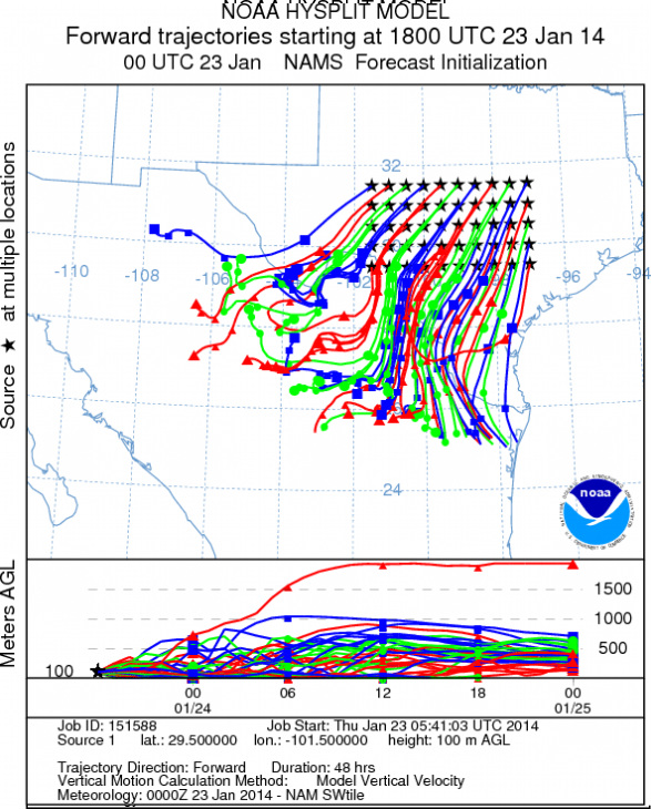
EDWARDS PLATEAU COMPOSITE
Prepared by: Estelle
Levetin (Faculty of Biological
Science, The
University of Tulsa, 800 S. Tucker Dr., Tulsa, OK 74104) and ) and Peter
K Van de Water (Department of Earth and Environmental Science, California State University Fresno,
2576 East San Ramon Avenue, M/S ST24, Fresno CA 93740-8039). This forecast gives the anticipated future track of
released Mountain Cedar pollen, weather conditions over the region and along the forecast pathway, and an estimated
time of arrival for various metropolitan areas.
Questions: Aerobiology Lab e-mail: pollen@utulsa.edu
Return to Forecasting Home Page