
The University of Tulsa
Mountain Cedar Pollen Forecast
Metropolitan Area |
Exposure Risk |
|
Dallas/Fort Worth |
High/Severe |
|
Austin |
High/Severe |
|
San Antonio |
High/Severe |
Date Issued: 25 January 2014
Mountain Cedar Location(s): Edwards Plateau, Texas
Regional Weather: Saturday/Sunday, January 25/26 TX/OK:.
The region today will rebound nicely from the cold conditions at the end of the week. Skies across Oklahoma today
will be mostly sunny with the high temperature expected to be in the lower 60s along the border region and in the
50s in central Oklahoma. Winds will be from the northwest at light to moderate conditions this afternoon and then
shift around to southwest this evening. Across Texas temperatures will also climb into the mid-60s with light
to moderate winds from the west and northwest. Skies will be sunny to the north shifting to partly cloudy and
mostly cloudy along the I-35 corridor from Dallas to San Antonio. On the Plateau mostly cloudy conditions will
begin the day but the skies will break-up during the day to partly cloudy conditions. Winds will be from the northwest
and west at light to moderate conditions. Overnight partly cloudy skies will dominate the region. Temperatures
will fall to the mid-30s in Oklahoma and across much of the Edwards Plateau. In the edge communities most areas
will only fall into the lower 40s. Winds will be from the south across the Edwards Plateau. In the remaining
areas winds will be from mixed directions and light. Tomorrow, the region will continue to warm with highs expected
region wide to be in the 70s. The Plateau will be in the mid-70s and even areas to the north along the border
with Oklahoma will reach 70. Winds will be from the south and southwest and light to moderate levels. Skies will
be mostly sunny. Tomorrow night conditions will be mostly clear along the border between Oklahoma and Texas as
well as across the Edwards Plateau. The skies form Austin north to Dallas will remain partly cloudy. Low temperatures
will fall a bit from today with lows in Oklahoma in the 20s but Texas remaining in the upper 30s and low 40s.
Winds in the communities surrounding the Edwards Plateau will start at light levels from the southwest, but later
move to a more northwesterly flow. The rest of the region will be under an overall north/northwest flow at light
to moderate conditions. Colder weather is expected early next week.
Trajectory weather: Air mass over central Texas will begin the day with mostly cloudy to partly cloudy conditions.
Initially winds will be moderate from the north and northwest, but these will turn early today with winds coming
from the south especially over the Edwards Plateau. Other areas will see an overall decline in winds strength
and most of the region will have mixed conditions and/or light and variable winds tonight. Highs today will be
in the mid-60s across the region and tonight lows will dip into the mid-30s on the Plateau and upper 30s into the
low 40s elsewhere. As the more southerly flow takes over during the day today, it will remain overnight and into
tomorrow. The trajectories will move to the north over the forecast period with dense air conditions, therefore
the trajectories will travel mostly at or near ground level. The trajectories show a south to north shift during
the evening today and tomorrow winds will be increasing and thus the extent of the push of air will be expanding
into southeast Oklahoma. Warm temperatures are expected tomorrow with most stations climbing into the 70s. These
conditions will be very good for pollination, entrainment and travel over the forecast period. Any entrained pollen
should remain within the region. After the late weeks cold conditions and precipitation, the overall skies should
have been cleared and thus release today will begin the process of building pollen back into the air across the
area.
OUTLOOK: *** High Threat Today and Severe Threat Tomorrow *** Conditions for pollen
release today and tomorrow will be excellent. Temperatures will be climbing from the twenties overnight but will
reach well into the 60s by this afternoon. Winds will be from the north and northwest early then switch to a
more southwesterly flow. Tomorrow conditions will be even better with the highs forecast to be in the 70s from
southern Oklahoma across Texas. Winds tomorrow will be moderate therefore entrainment and travel towards the northeast
is expected. We will be watching to see how well the pollen in the atmosphere returns from the cold conditions
and precipitation earlier in the week. Just prior to the incursion of Thursdays and Fridays weather system pollen
counts had begun to diminish a bit but there still seems to be ample pollen ready to be released. The very warm
conditions will present excellent conditions to test the overall progress of the pollination season.
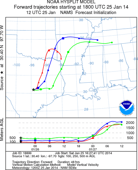
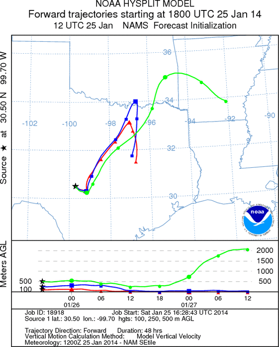
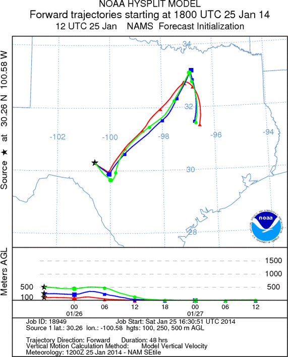
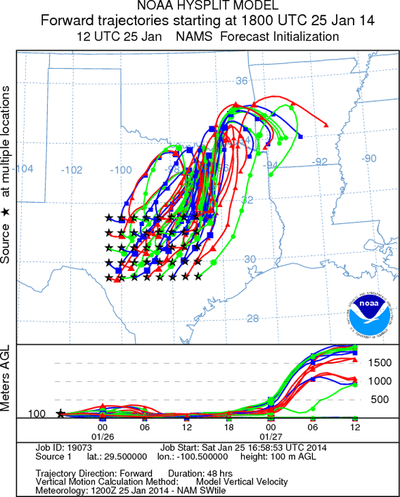
Trajectory Start (s) (shown by *
on map): Austin, TX; Junction, TX; Sonora, TX.
AUSTIN
JUNCTION
SONORA
EDWARDS PLATEAU COMPOSITE
Prepared by: Estelle
Levetin (Faculty of Biological
Science, The
University of Tulsa, 800 S. Tucker Dr., Tulsa, OK 74104) and ) and Peter
K Van de Water (Department of Earth and Environmental Science, California State University Fresno,
2576 East San Ramon Avenue, M/S ST24, Fresno CA 93740-8039). This forecast gives the anticipated future track of
released Mountain Cedar pollen, weather conditions over the region and along the forecast pathway, and an estimated
time of arrival for various metropolitan areas.
Questions: Aerobiology Lab e-mail: pollen@utulsa.edu
Return to Forecasting Home Page