
The University of Tulsa
Mountain Cedar Pollen Forecast
Metropolitan Area |
Exposure Risk |
|
Dallas/Fort Worth |
Low |
|
Austin |
Low |
|
San Antonio |
Moderate |
Date Issued: 27 January 2014
Mountain Cedar Location(s): Edwards Plateau, Texas
Regional Weather: Monday, January 27 TX/OK:.
The region today will be seeing an incursion of very cold air. Overnight winds have picked up significantly with
areas to the north Texas, experiencing 15 to 30 mile per hour gusts. Across Texas winds may exceed those conditions.
Dallas is expected to see gust nearing 45 miles per hour. Along with the very gusty winds will come cold atmospheric
conditions cooling the region significantly. High temperatures in Oklahoma City are only expected to get into
the mid 20s and the border area to the south into the low 30s. Across Texas the winds will dominate with strong
and gusty conditions. Winds speeds of 30 miles per hour will be common. In the surrounding communities of the
Edwards Plateau high temperatures will push to the 50 degree mark, but not much more. Across the Plateau high
temperatures will be in the low 40s and upper 30s for the daily high temperature. Overnight the clouds will build
from the partly cloudy and mostly cloudy conditions during the day. The skies will be mostly cloudy to cloudy
and very cold conditions will grip the region. There is an expectation of flurries in the Austin area and to the
west near Junction a 20% chance of sleet and snow. Temperatures across central and northern Texas will be in the
mid 20s and lower. The plateau communities should expect to be in the teens along with communities in the central
and southern portions of Oklahoma. Tomorrow cloudy to mostly cloudy conditions will remain across the Edwards
Plateau. Austin, San Antonio north towards Junction area all expected to have a chance (20%) for frozen precipitation.
High temperatures across the entire region will not get above the upper 30s. Winds will remain from the north
and northeast at moderate levels. Tomorrow night partly cloudy to cloudy conditions will remain. San Antonio
will still have a chance of frozen precipitation (20%). And temperatures will again drop into the teens in most
of the forecast area. The exceptions, with lows expected in the low to mid 20s will occur in the communities surrounding
the Edwards Plateau and northward up the I-35 corridor.
Trajectory weather: The air mass over central Texas will begin the day with mostly cloudy conditions. The
areas surrounding the Edwards Plateau and northwards towards the Dallas/Ft. Worth area will have partly cloudy
skies. The shift to a northeast wind overnight will be bringing very blustery conditions. Wind speeds of 30 miles
per hour gusting to 45 miles per hour are expected. Trajectories over the area will be pushed rapidly towards
the south and southwest. Very cold conditions will be building in with the days high temperatures in most areas
topping out in the low 50s. San Antonio will get into the mid-50s but the change towards cold conditions will
occur relatively rapidly. By this evening temperatures will have dropped into the 20s across the region. With
the high wind significant wind chill effects will be present. The winds will remain strong from the northeast.
Tomorrow high temperatures will struggle to get into the upper 30s. Winds will relax being moderate to strong
and there is a 20% chance of freezing rain, sleet, and snow in the edge communities extending westward out towards
Junction. Tomorrow night temperatures will be in the teens and low 20s, winds will remain from the north. The
cold conditions will bring heavy dense air to the region. With the combination of very cold conditions, cloudy
skies, and strong winds very little pollen release is expected. If the trees area able to release their pollen
it should move rapidly to the southwest.
OUTLOOK: ***Low to Moderate Threat Today
and Low Threat Tomorrow *** Conditions for pollen
release today and tomorrow will be poor in most parts of the Plateau, with very cold conditions building. However,
with the warm conditions yesterday there may still be some pollen in the atmosphere that will affect individuals
in the area, especially around San Antonio. Low temperatures over the forecast period will be in the teens in most
places. High temperatures will struggle to get into the 40s across the Plateau today, although the edge communities
will be in the 40s and 50s early, then tomorrow no area is expected to be outside of the 30s for their high temperature.
Winds will be from the north and northeast over the entire forecast and starting on Monday they will be very strong
declining towards tomorrow night. Saturdays and Sundays weather was very good for pollination, therefore it
is expected that pollen counts rebounded from the cold spell late last week. As we look back pollen had begun
to diminish a bit but there still seems to be ample pollen ready to be released as seen on days that warm up.
We continue to test the overall progress of the pollination season, and to date we have not observed an significant
drop off.
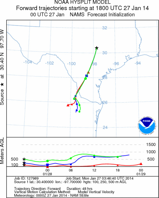
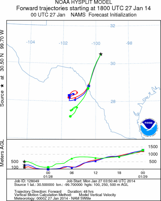
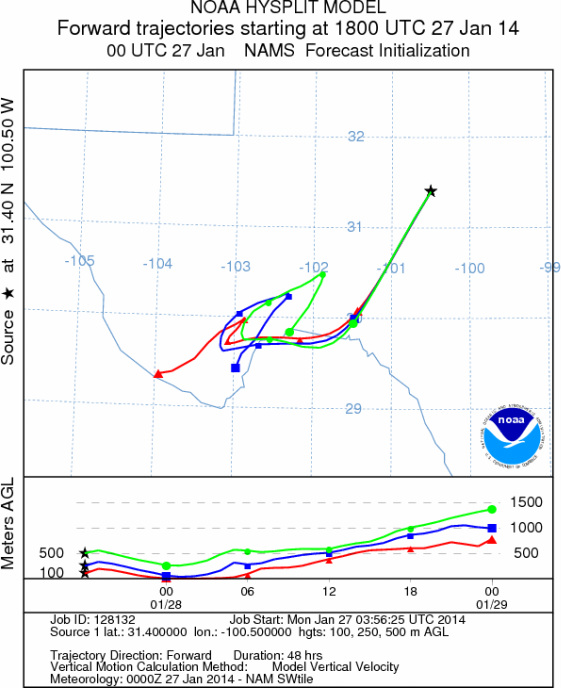
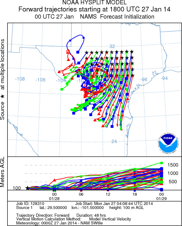
Trajectory Start (s) (shown by *
on map): Austin, TX; Junction, TX; Sonora, TX.
AUSTIN
JUNCTION
SONORA
EDWARDS PLATEAU COMPOSITE
Prepared by: Estelle
Levetin (Faculty of Biological
Science, The
University of Tulsa, 800 S. Tucker Dr., Tulsa, OK 74104) and ) and Peter
K Van de Water (Department of Earth and Environmental Science, California State University Fresno,
2576 East San Ramon Avenue, M/S ST24, Fresno CA 93740-8039). This forecast gives the anticipated future track of
released Mountain Cedar pollen, weather conditions over the region and along the forecast pathway, and an estimated
time of arrival for various metropolitan areas.
Questions: Aerobiology Lab e-mail: pollen@utulsa.edu
Return to Forecasting Home Page