
The University of Tulsa
Mountain Cedar Pollen Forecast
Metropolitan Area |
Exposure Risk |
|
Dallas/Fort Worth |
Low |
|
Austin |
Low |
|
San Antonio |
Low |
Date Issued: 28 January 2014
Mountain Cedar Location(s): Edwards Plateau, Texas
Regional Weather: Tuesday, January 28 TX/OK:.
The region today will remain very cold with the effects of the latest blast of cold arctic air. To the north
skies will be clearing after the chance of some light flurries overnight. Temperatures will be climbing from very
cold conditions but todays high temperatures will only be in the mid-30s. Winds will be from the northeast at
moderate conditions across the region. Cloudy conditions will remain across central Texas with the chance of frozen
precipitation along with rain and sleet between San Antonio and Waco. The best conditions across the Edwards Plateau
will get high temperatures at or just above the 40 degree mark but with precipitation across the area. Tonight
very cold conditions drop back in with the warmest area, San Antonio expecting to be in the mid-20s. Most of the
region will be in the low to mid-teens. Winds will be from the north and northeast at moderate to light levels.
Tomorrow the warm-up will begin with mostly sunny skies by the afternoon. Winds will be from the southeast across
the Plateau and from the northeast in the surrounding communities. High temperatures will be in the mid- to upper
40s in most areas with the lower 50s across the Edwards Plateau. Wind will begin as light conditions initially
but build to more moderate conditions during the afternoon. Tomorrow night lows will be in the upper 20s and low
30s across the region. Winds will be from the south at light to moderate levels,
Trajectory weather: The air mass over central Texas will begin the day with mostly cloudy conditions and
a mix of precipitation across the southern Edwards Plateau region. The areas surrounding the Edwards Plateau have
seen a wide range of sleet, snow and rain over the last 24 hours. The northeast wind will continue today at moderate
levels continuing to bring cold air into the area. Overnight very cold conditions will settle in the region in
the mid 20s to the low teens. Winds will remain from the north across most of the area but the southwestern most
communities will begin to see a shift to a southerly direction. Tomorrow areas to the north and across the Edwards
Plateau will experience stronger winds from the south and southeast. Winds will build from light to moderate levels
over the afternoon. Skies will begin to clear during the day and high temperatures will build during the day into
the upper 40s and just into the low 50s. Tomorrow night a southerly flow will take over the region and lows will
be in the mid to upper 20s across the Edwards Plateau and in the low 30s in the surrounding communities. Skies
will be mostly clear. The dominant northerly winds over the forecast area will result in any pollen released
moving southward today and then northward tomorrow on the switch to southerly winds. However with the very cold
conditions last night and today, along with frigid condition tomorrow night it is expected that the release of
pollen will be minimal.
OUTLOOK: ***Low Threat today and Low to Moderate Threat Tomorrow
*** Conditions for pollen release today and tomorrow will be poor, with very cold conditions. Low temperatures
over the forecast period will be in the teens in most places. High temperatures will struggle to get to the 40
degree mark in the warmest areas on the Edwards Plateau. There continues to be the chance of precipitation across
the southern Edwards Plateau region with a 20% chance of light snow and freezing precipitation. Tonight temperatures
will fall into the teens across Oklahoma and the Edwards Plateau. The communities surrounding the Edwards Plateau
will be in the low 20s. The cold conditions should delay any pollen release tomorrow as the high temperatures
will struggle to get into the 40s in most places and just reach the 50s on the western side of the Edwards Plateau.
We will be watching to see if and by how much the pollen counts rebound as the warm-up continues this week. As
we look back to the last really good conditions pollen had begun to diminish a bit We continue to test the overall
progress of the pollination season, and to date we have not observed an significant drop off.
Trajectory Start (s) (shown by *
on map): Austin, TX; Junction, TX; Sonora, TX.
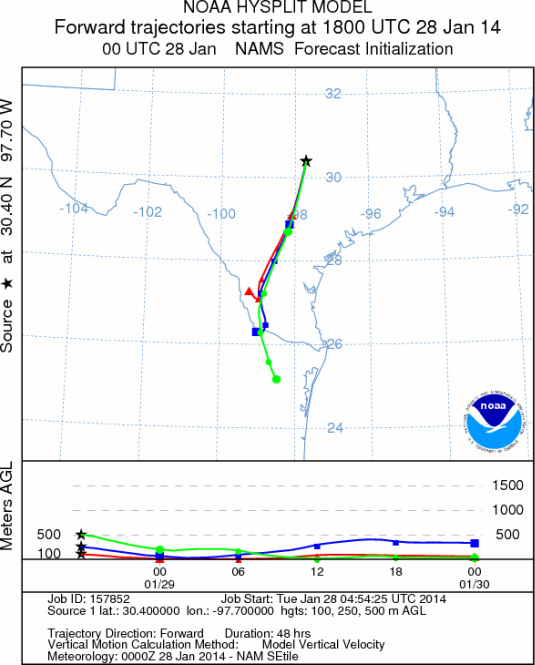
AUSTIN
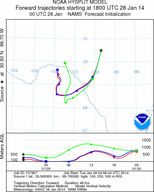
JUNCTION
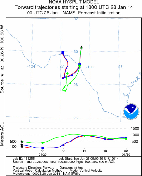
SONORA
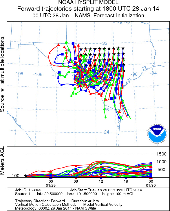
EDWARDS PLATEAU COMPOSITE
Prepared by: Estelle
Levetin (Faculty of Biological
Science, The
University of Tulsa, 800 S. Tucker Dr., Tulsa, OK 74104) and ) and Peter
K Van de Water (Department of Earth and Environmental Science, California State University Fresno,
2576 East San Ramon Avenue, M/S ST24, Fresno CA 93740-8039). This forecast gives the anticipated future track of
released Mountain Cedar pollen, weather conditions over the region and along the forecast pathway, and an estimated
time of arrival for various metropolitan areas.
Questions: Aerobiology Lab e-mail: pollen@utulsa.edu
Return to Forecasting Home Page