
The University of Tulsa
Mountain Cedar Pollen Forecast
Metropolitan Area |
Exposure Risk |
|
Dallas/Fort Worth |
High |
|
Austin |
High |
|
San Antonio |
High |
Date Issued: 29 January 2014
Mountain Cedar Location(s): Edwards Plateau, Texas
Regional Weather: Wednesday, January 29 TX/OK:.
The region today will begin very cold with the Edwards Plateau in the teens and the surrounding communities in
the mid to low twenties. Skies will be clear as the push of cold air is far south over the northern Gulf of Mexico
and to the east through northern Florida. Today will be a warm up from the cold conditions with sunny skies across
the region and temperatures building back into the upper 40s. Winds will be from the south at light conditions
over the Edwards Plateau and to the north into southern Oklahoma. Along the edge of the Plateau northeasterly breezes
will remain early eventually switching to a southerly flow overnight. Winds will be light building a bit to moderate
conditions tonight. Then tomorrow much stronger winds will build during the day. Overnight temperatures will fall
into the 30s across the region, being much warmer than the last few evenings. Skies will remain mostly clear to
clear with sunny to mostly sunny skies on Thursday. Tomorrow the warming continues with the western Edwards Plateau
heading back into the 70 degree range. The remaining areas of the Edwards Plateau will be in the upper 60s. Winds
will build from the south to moderately strong conditions during the day. 20 to 25 mile an hour winds will be common
across the area with gusts as high as 35 miles per hour in the Dallas/Ft. Worth metro area. The warm southerly
breezes will build in partly cloudy conditions tomorrow night with low temperatures mild. In Oklahoma and across
the western Edwards Plateau the temperatures will fall into the upper 30s and across the central Texas region lows
in the mid to upper 40s will be common.
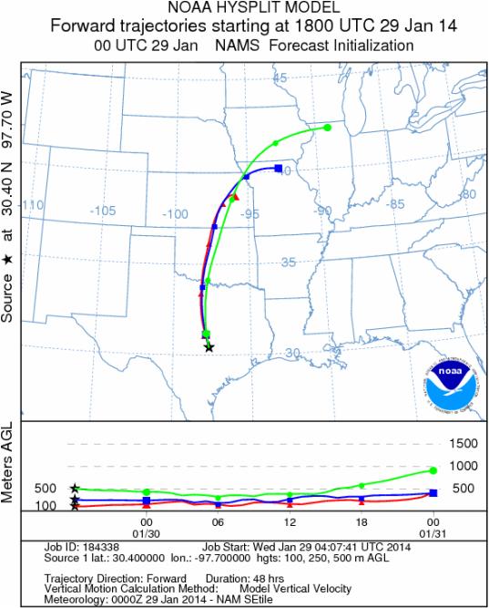
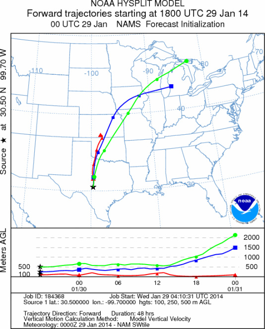
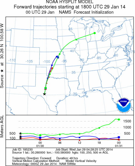
Trajectory weather: The air mass over central Texas will begin the day with sunny to mostly sunny conditions
and a southerly flow establishing itself over the region. Cold conditions last night will begin to wane as warmer
air along with clear skies facilitates the overall warming. The high temperatures today will be heading into the
upper 40s across the region. With the establishment of the south to north flow, winds will begin to build with
light to moderate conditions today and tonight and then strong winds tomorrow from the south. Tomorrow afternoon
winds are expected to be in the 20 to 25 miles per hour range. Gusts in northern Texas are expected to reach into
the 30 mile per hour range tomorrow afternoon. The overall flow will take the trajectories northward across Oklahoma
and into the upper Midwest. Cold conditions overnight may retard the release of pollen early today as the trees
begin their warming. Traditionally we have felt that conditions in the low 40 degree range are not particularly
good for pollination. However, there has been lots of pollen being recorded recently even through some of the conditions
have been marginal. Because of this, we expect the morning to begin with low levels but that as the day progresses
greater amounts will be released. With the building winds then entrainment and travel will occur. Areas to the
north should be in line to receive pollen from across the Texas and southern Oklahoma source regions. Tomorrow,
stiff winds and warm conditions will provide even better conditions for release, entrainment and travel northward.
OUTLOOK: *** Moderate to High Threat today and Severe Threat Tomorrow
*** Conditions for pollen release today will start with cold conditions but the region will be warming under
clear, sunny skies. Winds will begin the day light and build overnight towards very breezy conditions tomorrow.
With the warming the trees will see temperatures this afternoon at levels that we often see results in pollination.
Winds will be dominantly from the south and any pollen released and entrained within the atmosphere will move towards
the north. The lingering effects of the cold conditions over the last couple of days will keep the trajectories
initially near ground level, thus pollen should be more susceptible to impaction and removal from the air stream.
Tonight and tomorrow, especially, the winds will build to strong levels. Temperatures are heading up with high
temperatures tomorrow in the mid- to upper 60s and low 70s on the western Edwards Plateau. The trajectories will
stay near the ground today, but tomorrow with warmer conditions they will be more buoyant and thus travel will
take the pollen northwards across Okalhoma, eastern Kansas towards the border between Missouri and Iowa. We continue
to watch to see if and by how much the pollen counts rebound as the warm-up occurs this week. As we look back to
the last really good conditions pollen had begun to diminish a bit We continue to test the overall progress of
the pollination season, and to date we have not observed an significant drop off.
Trajectory Start (s) (shown by *
on map): Austin, TX; Junction, TX; Sonora, TX.
AUSTIN
JUNCTION
SONORA
EDWARDS PLATEAU COMPOSITE
Prepared by: Estelle
Levetin (Faculty of Biological
Science, The
University of Tulsa, 800 S. Tucker Dr., Tulsa, OK 74104) and ) and Peter
K Van de Water (Department of Earth and Environmental Science, California State University Fresno,
2576 East San Ramon Avenue, M/S ST24, Fresno CA 93740-8039). This forecast gives the anticipated future track of
released Mountain Cedar pollen, weather conditions over the region and along the forecast pathway, and an estimated
time of arrival for various metropolitan areas.
Questions: Aerobiology Lab e-mail: pollen@utulsa.edu
Return to Forecasting Home Page