
The University of Tulsa
Mountain Cedar Pollen Forecast
Metropolitan Area |
Exposure Risk |
|
Dallas/Fort Worth |
High |
|
Austin |
High |
|
San Antonio |
High |
Date Issued: 31 January 2014
Mountain Cedar Location(s): Edwards Plateau, Texas
Regional Weather: Friday, January 31 TX/OK:.
The region today will have a mix of conditions with overall warm weather for the forecast period. To the north
in Oklahoma the day will begin with mostly sunny skies along the border with Texas and partly cloudy conditions
further north. In Texas partly cloudy skies will prevail across the Edwards Plateau and in the surrounding communities.
In those edge communities partly sunny to mostly sunny conditions will develop during the day. Early there will
be a chance of patchy fog and drizzle. Winds will be from the south across the region bringing warm humid air further
north. High temperatures will be in the low to mid 70s across the area. In Oklahoma the southern border region
will get into the upper 60s but central Oklahoma will remain colder with highs expected in the upper 40s. Tonight
mostly cloudy skies will build back in to the region. In Texas the lows will be mild with upper 40s across the
Edwards Plateau and 50s and 60s in the edge communities northward along the I-35 corridor. After midnight patchy
fog and drizzle can be expected in areas. Winds will remain from the south at moderate conditions. The edge communities
will see higher wind gusts in the 20 to 25 miles per hour range. In Oklahoma temperatures will be much colder overnight
with lows along the southern border in the upper 30s and Oklahoma City in the upper 20s. Tomorrow southern Oklahoma
will see a 20% chance of rain and highs in the lower 50s. Overnight the light and variable winds will be overtaken
by a more northerly flow. Skies will be partly cloudy tomorrow. The partly cloudy to cloudy conditions will extend
southward in the morning across Texas. On the Edwards Plateau the cloudy conditions will persist, while in the
edge communities partly sunny skies will eventually emerge. There will be a chance of drizzle and patchy morning
fog in most areas with the southern edge communities potentially getting a shower from the cloudiness. Temperatures
across Texas will return back into the 70 degree mark. Winds will remain from the south in most areas, but to the
southwest on the plateau northwest and westerly air movement will begin to move into the region. Tomorrow night
mostly cloudy conditions will prevail across Texas. Low temperatures will cool being in the mid-30s overnight.
In the edge communities lows will remain mild and from San Antonio to Austin there will be a 20% to 30% chance
of showers. The overall atmospheric flow will turn coming from the north and northeast at moderate levels.
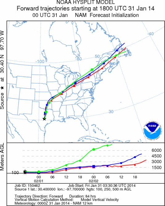
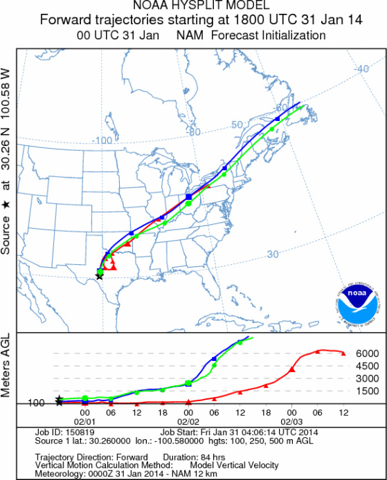
Trajectory weather: The air mass over central Texas will begin the day partly to mostly cloudy conditions
and a southerly flow over the region at moderate levels. The southerly flow will be bringing humidity northward
creating overnight fog and potential drizzle today and tomorrow. Areas across northern Texas will see gusty conditions.
Temperatures will be in the mid- to upper 70s across the area. The atmosphere will begin the day relatively stable
but will become more buoyant as the trajectories push northward into Oklahoma and strong winds will carry the trajectories
long distances towards the northeastern United States. . The southerly flow will bring anything entrained within
the air column towards the north. The forecast calls for the southerly winds to remain in this configuration today
through tomorrow. Winds will be moderate to strong at upper elevations across the region. The 48 hour trajectories
show the air mass moving initially northward into central Oklahoma then turning to the northeast during the forecast
period. As the day warms and the skies begin to clear pollen release is expected throughout the region. The windy
and atmospheric conditions will aid the entrainment as well as the travel of the pollen to the north.
OUTLOOK: *** High Threat today and High Threat Tomorrow *** Conditions for pollen
release today and tomorrow will be good with warming but cloudy to partly cloudy skies. Winds will begin the day
at moderate levels from the south building to strong conditions this afternoon in some of the edge communities.
This morning in the edge communities, patchy fog and drizzle will be common. High temperatures across Texas today
will reach into the low to mid 70s creating excellent conditions for pollen release, but high humidity may hinder
entrainment thus the overall load that travels over long distances may be reduced. Overnight moderate winds and
a return to humid conditions in the communities surrounding the Edwards Plateau will occur. Breezy conditions will
be at moderate levels again tomorrow. Temperatures tomorrow will climb back into the 70s and but winds will be
more moderated and the peripheral areas will see a shift towards a more northerly, eventually becoming northeasterly
change tomorrow afternoon and overnight. Tomorrow night lows will remain seasonal with 30s expected across the
Edwards Plateau and low 40s up to 50 degrees in the edge communities. We continue to watch to see if and by how
much the pollen counts rebound as the warm-up occurs this week. As we look back to the last really good conditions
pollen had begun to diminish a bit We continue to test the overall progress of the pollination season.
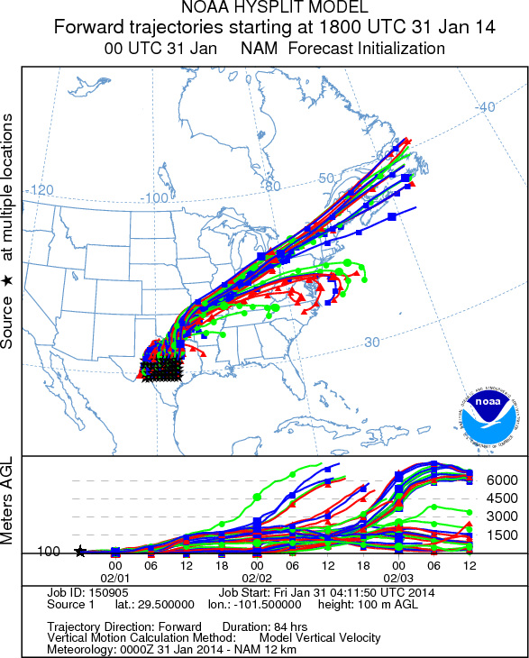
Trajectory Start (s) (shown by *
on map): Austin, TX; Junction, TX; Sonora, TX.
AUSTIN
JUNCTION
SONORA
EDWARDS PLATEAU COMPOSITE
Prepared by: Estelle
Levetin (Faculty of Biological
Science, The
University of Tulsa, 800 S. Tucker Dr., Tulsa, OK 74104) and ) and Peter
K Van de Water (Department of Earth and Environmental Science, California State University Fresno,
2576 East San Ramon Avenue, M/S ST24, Fresno CA 93740-8039). This forecast gives the anticipated future track of
released Mountain Cedar pollen, weather conditions over the region and along the forecast pathway, and an estimated
time of arrival for various metropolitan areas.
Questions: Aerobiology Lab e-mail: pollen@utulsa.edu
Return to Forecasting Home Page