
The University of Tulsa
Mountain Cedar Pollen Forecast
Metropolitan Area |
Exposure Risk |
|
Dallas/Fort Worth |
Low |
|
Austin |
Moderate |
|
San Antonio |
Moderate |
Date Issued: 1 February 2014
Mountain Cedar Location(s): Edwards Plateau, Texas
Regional Weather: Saturday/Sunday, February 1/2 TX/OK:.
The region today will have a mix of conditions with overall warm weather for the forecast period to the south
and a push of much colder air over Oklahoma moving into northern Texas. In Oklahoma today mostly cloudy conditions
will occur with the chance of precipitation. There is a 20% chance of rain along the border area, with areas to
the north having more frozen precipitation. In southern Oklahoma high temperatures will move into the mid-50s
during the day. Winds will be between 10 and 15 miles per hour from the north. The northerly winds will occur
as far south as the front that is pushing into Texas. Winds will be from the south at light to moderate conditions
in the edge communities and from the west to northwest over the Plateau. As the front moves through an area the
switch in wind direction will cause gusty conditions. Tonight mostly cloudy conditions will build in to the north
and partly cloudy changing to cloudy conditions will occur over the Plateau and its surrounding communities. Low
temperatures in Oklahoma will be well below freezing. Across Texas low temperatures will be above freezing and
seasonal. The Plateau will be in the upper 30s and the surrounding communities in the mid to upper 40s. Winds
will be switching from todays southerly flow to a north and northeasterly flow with colder atmosphere behind them.
The edge communities should expect gusty conditions as the change occurs. Tomorrow cloudy conditions will cover
the region. There will be a 70% chance of rain from the Dallas/Ft. Worth metro region north into southern Oklahoma.
The Oklahoma region will be in the lower 30s thus some of the precipitation may fall as snow, sleet or freezing
rain. In the Dallas/Ft. Worth area low temperatures are expected to be in the upper 30s so precipitation will
fall as rain. Winds will be from the north at light to moderate conditions. Southward, by tomorrow the front
will have pushed south of the Edwards Plateau. The western area of the Plateau will have a 40% chance of showers
declining to the east side of the plateau where a 20% chance of rain showers will occur. Winds will be from the
north at moderately strong levels. The edge communities should expect gusty conditions. High temperatures will
be mostly in the 30s during the day. The edge communities will rise to the mid-40s to low 50s. Winds will be
moderately strong from the north. Tomorrow night low temperatures will fall into the 20s across Oklahoma and on
the Edwards Plateau. The edge communities will be in the lower 30s. Winds will remain from the north at light
levels over the Plateau and strong gusty conditions in the edge communities.
Trajectory weather: The air mass over central Texas will begin the day with partly to mostly cloudy conditions
and a southerly flow over the region at moderate levels in the communities surrounding the Plateau. To the north
and the west the winds will be shifting with colder conditions heading southward. This morning there was a chance
of drizzle as well as patchy fog in the surrounding communities. That will continue into the evening hours with
a chance of showers. On the Plateau the winds will be shifting to a flow from the west and northwest. The northerly
winds will be building across the region as we go into tonight and for tomorrow and tomorrow night. With the northerly
winds the cold front will continue to move south and as that happens temperatures will be falling. Tomorrow, in
the southern areas of the forecast area, todays temperatures in the 60s to low 70s will be replaced with 40s and
50s with the Plateau staying in the 30s. Across the region tomorrow there will be a significant chance of showers
in southern Oklahoma and around the Dallas/Ft. Worth metro region. Further south the chance of rain will be in
the 20% range. Winds will remain from the north at moderate conditions with some areas having gusts in the 25
to 30 miles per hour range. Once the northerly flow establishes itself it will dominate tomorrow and tomorrow
evening.
OUTLOOK: *** High Threat today and Low to Moderate
Threat Tomorrow *** Conditions for pollen release today and tomorrow will be marginal with warmer conditions
today, especially south of the front that is moving through the area, potentially being the major contributor to
the pollen load. As the front moves in, winds will shift to a dominant north to south flow. Colder conditions
will also bring moisture and the chance of precipitation and showers to the north today spreading southward across
the Texas forecast area tomorrow. This afternoon, tonight and tomorrow will see cooler conditions. This morning
in the edge communities, patchy fog and drizzle will be common. High temperatures across Texas today will reach
into the low to mid 70s south of the cold front but these warm conditions will be short lived as colder conditions
will drop southward. High humidity may hinder entrainment thus the overall load that travels over long distances
should be reduced. The greater humidity and the increasing chance of showers across the region results in a low
to moderate forecast for tomorrow. Winds over the forecast period will be moderate with the Edge communities having
gusty conditions. We continue to watch to see if and by how much the pollen counts rebound as the warm-up occurs
this week. As we look back to the last really good conditions pollen had begun to diminish a bit. We continue
to test the overall progress of the pollination season.
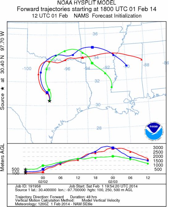
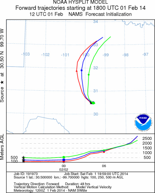
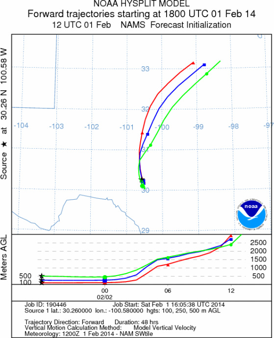
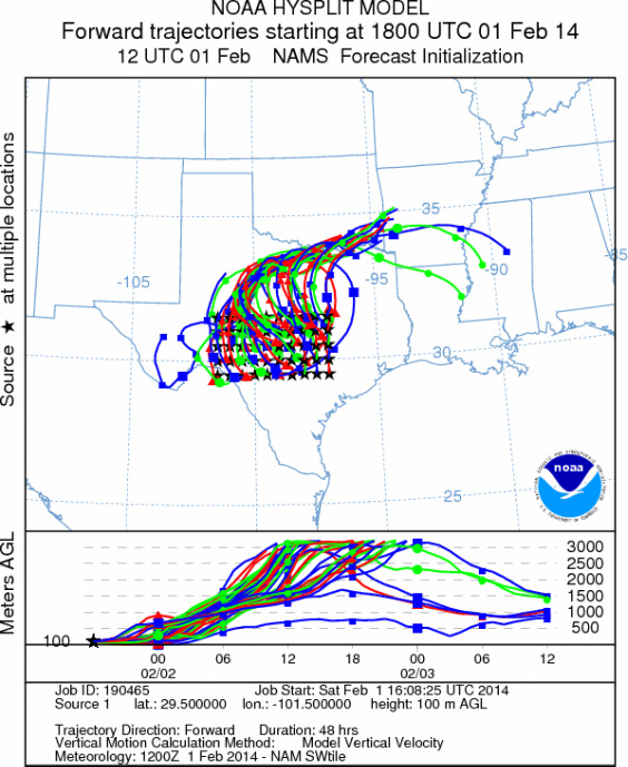
Trajectory Start (s) (shown by *
on map): Austin, TX; Junction, TX; Sonora, TX.
AUSTIN
JUNCTION
SONORA
EDWARDS PLATEAU COMPOSITE
Prepared by: Estelle
Levetin (Faculty of Biological
Science, The
University of Tulsa, 800 S. Tucker Dr., Tulsa, OK 74104) and ) and Peter
K Van de Water (Department of Earth and Environmental Science, California State University Fresno,
2576 East San Ramon Avenue, M/S ST24, Fresno CA 93740-8039). This forecast gives the anticipated future track of
released Mountain Cedar pollen, weather conditions over the region and along the forecast pathway, and an estimated
time of arrival for various metropolitan areas.
Questions: Aerobiology Lab e-mail: pollen@utulsa.edu
Return to Forecasting Home Page