
The University of Tulsa
Mountain Cedar Pollen Forecast
Metropolitan Area |
Exposure Risk |
|
Dallas/Fort Worth |
Moderate |
|
Austin |
Moderate to High |
|
San Antonio |
Moderate to High |
Date Issued: 3 February 2014
Mountain Cedar Location(s): Edwards Plateau, Texas
Regional Weather: Monday, February 3 TX/OK:.
The region will begin today with partly cloudy to mostly cloudy skies and seasonal temperatures on the cold side.
In Oklahoma along the border with Texas the high temperatures will remain in the low 30s today. To the south
warmer conditions will build in but not by much with the highs across the region today being in the low 50s. In
Oklahoma winds will be light and variable. Across Texas the winds will be from the northeast in the edge communities
to the north up the I-35 corridor. On the Plateau they will be from southeast. Winds will be mostly light across
the region. Tonight mostly cloudy skies will return across the area as will the chance of rain. In Oklahoma
will be the chance of a wintery mix with a 40% plus of snow and freezing rain. Low temperatures will be in the
upper 20s and winds will be light from the east. Across Texas the chance of precipitation will be from 50% in
the north to 20% on the western Edwards Plateau. Low temperatures will be in the mid-30s across the Plateau and
to the mid-40s in the surrounding communities. An overall light flow from the south and southeast will occur over
the region. Tomorrow skies will begin to clear with a quick warmup in store. Most of the region will begin the
day with a continuation of the clouds and rain. In Oklahoma tomorrow will see a 40% to 50% chance of precipitation
with temperatures remaining in the low 40s along the border and mid-30s. South across central Texas highs tomorrow
will be in the low to mid 60s. Winds will be from the west at moderate conditions and skies will begin partly
cloudy but be clearing through the day. In the Edge communities the morning will remain cloudy and there will
be a continuation of rainy conditions. High temperatures will be reaching into the low 60s and the predominant
westerly winds will be at moderate levels. Tomorrow night mostly clear skies will occur across the southern plains.
Temperatures will be in the teens in southern Oklahoma and drop into the 20s across the Edwards Plateau. In the
edge communities warmer conditions will persist with lows in the upper 30s and low 40s. Winds will be from the
north at moderate levels across the region.
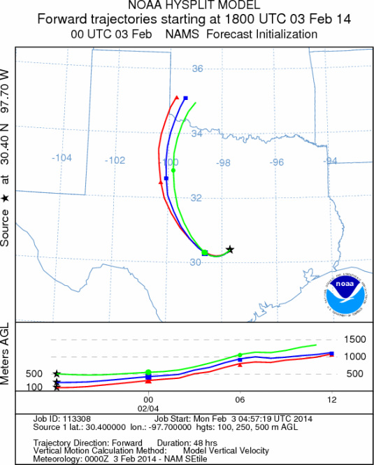
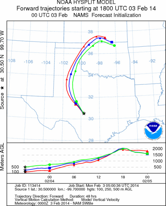
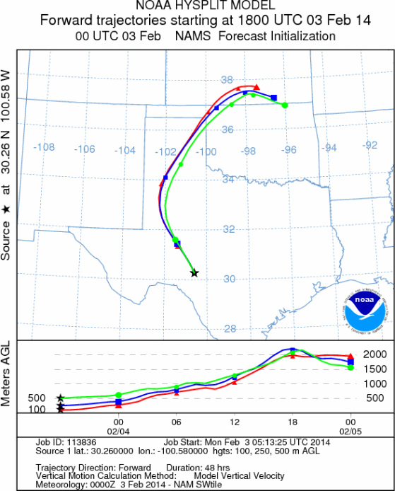
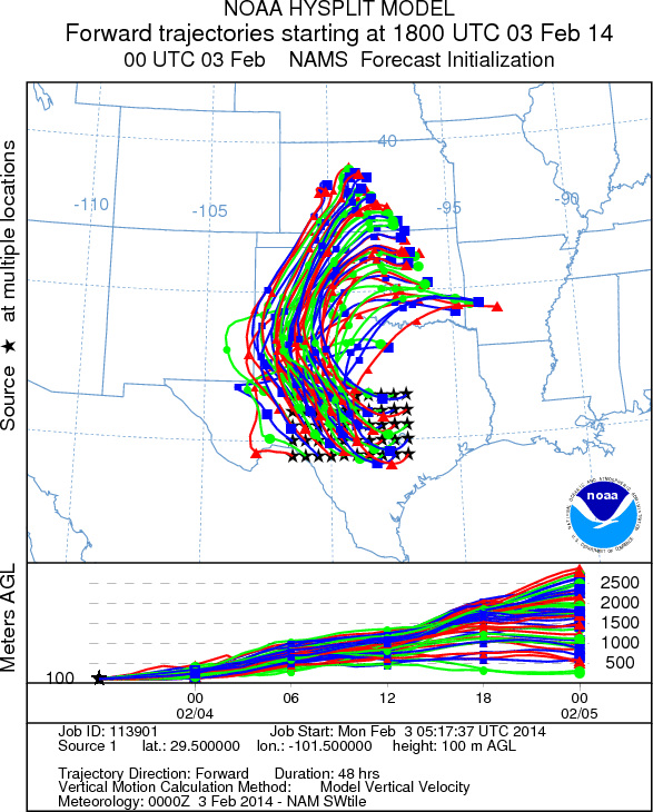
Trajectory weather: The air mass over central Texas will begin the day with partly to mostly cloudy conditions
and a southeasterly flow over the Plateau and a northeasterly flow in the edge communities. Winds will be light.
High temperatures today will remain in the mid to upper 40s to low 50s. Tonight mostly cloudy conditions will
build in with a 40% to 50% chance of rain starting in Dallas moving south down the I-35 corridor. On the Edwards
Plateau the chance of precipitation drops to 20%. Low temperatures will be above freezing but in the mid to upper
30s and low 40s. Tomorrow the edge communities will retain their chance of precipitation in the morning but that
will clear and skies will be mostly sunny in the afternoon. Temperatures will warm with high readings in the 60s
and the areas furthest south toying with the low 70s. Winds will be from the west and build from moderate to strong
conditions across the Plateau. Tomorrow night lows will be in the 20s and winds from the northeast on the Edwards
Plateau. In the edge communities warmer conditions will prevail and winds will be from the north. The atmosphere
will be buoyant today and the winds will move the air over Texas initially towards the northwest on southeasterly
wind, then eventually tomorrow a more westerly wind will bring them back over northern Texas and central Oklahoma.
The northward migration will eventually encounter a northerly wind tomorrow evening bringing them back southward.
Overall winds will not be strong but he atmosphere will be buoyant. Tonight and tomorrow morning most of the
northern areas will be subject to precipitation which tends to clean the skies of pollen and other entrained particles.
OUTLOOK: *** Moderate Threat Today and High Threat Tomorrow
*** Conditions for pollen release today will be marginal with warming conditions and temperatures in the upper
40s and low 50s. The warming from the weekend will bring high temperatures across the region into the mid 40s
to just leaking into the low 50s across the Edwards Plateau and in the edge communities. Going into the evening
the chance of precipitation will be building. The greatest chance tonight and tomorrow will be in the edge communities.
Tomorrow warm conditions and clearing skies with temperatures back in the 60s and low 70s will result in a high
threat. By tomorrow night winds will be from the north once again and cooling conditions area expected. The trajectories
will be buoyant and with the southerly winds today and tonight changing to westerly tomorrow will result in any
pollen that is entrained moving north off of the Edwards Plateau towards the border region with Oklahoma and into
central and northern Oklahoma. We continue to watch to see if and by how much the pollen counts rebound. The current
forecast presents a mix of weather conditions and that will continue into the foreseeable future. As we look back
many of the pollen levels have begun to diminish. We continue to test the overall progress of the pollination
season.
Trajectory Start (s) (shown by *
on map): Austin, TX; Junction, TX; Sonora, TX.
AUSTIN
JUNCTION
SONORA
EDWARDS PLATEAU COMPOSITE
Prepared by: Estelle
Levetin (Faculty of Biological
Science, The
University of Tulsa, 800 S. Tucker Dr., Tulsa, OK 74104) and ) and Peter
K Van de Water (Department of Earth and Environmental Science, California State University Fresno,
2576 East San Ramon Avenue, M/S ST24, Fresno CA 93740-8039). This forecast gives the anticipated future track of
released Mountain Cedar pollen, weather conditions over the region and along the forecast pathway, and an estimated
time of arrival for various metropolitan areas.
Questions: Aerobiology Lab e-mail: pollen@utulsa.edu
Return to Forecasting Home Page