The University of Tulsa
Mountain Cedar Pollen Forecast

Metropolitan Area |
Exposure Risk |
|
Oklahoma City |
Low |
|
Tulsa |
Low |
|
St. Louis MO |
Low |
Date Issued: 4 February 2014
Mountain Cedar Location(s): Arbuckle Mountains, OK
Regional Weather: Tuesday, February 4 TX/OK:.
The region will begin today with cloudy skies and cold conditions to the north but warm conditions across the
Edwards Plateau. In Oklahoma high temperatures will be in the mid-30s in Oklahoma City and low 40s southward across
the border into the Dallas/Ft. Worth metro region. There will be a significant chance of precipitation in these
communities with it falling as snow to the north and rain in northern Texas following but east of the I-35 corridor.
To the south across the Edwards Plateau mostly cloudy conditions will begin the day but sunny conditions will break
out as the day progresses. Patchy fog will be common in the morning hours. High temperatures today will be in
the mid- to low 60s with winds starting at moderate conditions from the southwest, then rotating during the afternoon
to a more westerly condition. Winds from the west will be more moderate with some areas have strong wind conditions.
In the edge communities, temperatures will be another five degrees warmer with San Antonio expected to get to
70 degrees. The edge communities will have a chance (20%) of rain this morning but clearing will begin as the
day progresses. Tonight low temperatures will fall into the 20s and 30s across the Edwards Plateau and the edge
communities. Winds will switch again coming from the north and bringing cold air into the region. The Plateau
will fall into the upper 20s to mid-30s, the edge communities will be in the mid-30s. There will be colder conditions
to the north with the Dallas/Ft. Worth area falling to the upper 20s and along the border with Oklahoma readings
will be in the upper teens with Oklahoma City expected in the single digits. Tomorrow, partly cloudy skies will
greet the day with high temperatures forecast for southern Oklahoma in the mid-20s. The dominant northerly winds
will bring cold air across the region and high temperatures across Texas will be in the 30s to low 40s on the
Edwards Plateau, and in the upper 40s to low 50s in the edge communities . Winds will be from the north and northeast
at moderate to strong conditions. The Dallas/Ft. Worth area will see gust of up to 30 miles per hour. Tomorrow
night the entire region will fall below freezing with the Edwards Plateau in the low 20s and temperatures dropping
northward. The border region with Oklahoma will be in the low teens and Oklahoma City will be in the single digits
again. Winds will remain from the north at moderate winds strength.
Trajectory weather: The air mass over southern Oklahoma will begin the day with cloudy conditions and light
and variable winds. High temperatures today will remain in the upper 30s and low 40s. There was a 50% chance
of snow and rain overnight into the morning hours. Winds today will be turning coming from the north with more
cold air. Tonight mostly cloudy skies will return and low temperatures will be very cold with the area being in
the upper teens. Winds from the north will continue and begin to build across the region. Tomorrow the high temperatures
are expected to be in the teens to low 20s. Skies will be mostly to partly cloudy and winds will continue from
the north. Tomorrow night a 20% chance of snow will occur and low temperatures area expected in the low teens
along the border and in the single digits north in Oklahoma City. Winds will continue at moderate levels form
the northeast.
OUTLOOK: *** Low Threat Today and Low Threat Tomorrow *** Conditions for pollen
release today and tomorrow will be poor with cold conditions and temperatures in the 30s and low 40s today and
then tomorrow temperatures will not get above freezing. Today there is a significant chance of snow across the
area, and many places have already had some accumulation. This will continue into the morning. Poor conditions
for pollination are expected over the entire forecast period. By tomorrow the strong northerly winds will drive
temperatures into the teens and low 20s for the highs. The overall trend of pollen counts seems to be waning.
The current forecast presents a mix of weather conditions and that will continue into the foreseeable future.
As we look back traditionally we are getting close to the end of the season. We continue to test the overall
progress of the pollination season as it nears its end.
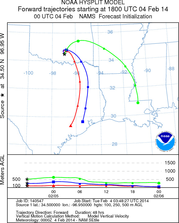
Trajectory Start (s) (shown by black
star on map): Davis, OK.
Prepared by: Estelle
Levetin
(Faculty
of Biological Science, The University of Tulsa, 800 S. Tucker Dr., Tulsa, OK 74104) and Peter
K Van de Water
(Department of Earth and Environmental Science, California State University Fresno, 2576 East San Ramon Avenue,
M/S ST24, Fresno CA 93740-8039). This forecast gives the anticipated future track of released Mountain Cedar pollen,
weather conditions over the region and along the forecast pathway, and an estimated time of arrival for various
metropolitan areas.
Questions: Aerobiology Lab e-mail: pollen@utulsa.edu
Return to Forecasting Home Page