
The University of Tulsa
Mountain Cedar Pollen Forecast
Metropolitan Area |
Exposure Risk |
|
Dallas/Fort Worth |
Low |
|
Austin |
Moderate |
|
San Antonio |
High |
Date Issued: 4 February 2014
Mountain Cedar Location(s): Edwards Plateau, Texas
Regional Weather: Tuesday, February 4 TX/OK:.
The region will begin today with cloudy skies and cold conditions to the north but warm conditions across the
Edwards Plateau. In Oklahoma high temperatures will be in the mid-30s in Oklahoma City and low 40s southward across
the border into the Dallas/Ft. Worth metro region. There will be a significant chance of precipitation in these
communities with it falling as snow to the north and rain in northern Texas following but east of the I-35 corridor.
To the south across the Edwards Plateau mostly cloudy conditions will begin the day but sunny conditions will break
out as the day progresses. Patchy fog will be common in the morning hours. High temperatures today will be in
the mid- to low 60s with winds starting at moderate conditions from the southwest, then rotating during the afternoon
to a more westerly condition. Winds from the west will be more moderate with some areas have strong wind conditions.
In the edge communities temperatures will be another five degrees warmer with San Antonio expected to get to 70
degrees. The edge communities will have a chance (20%) of rain this morning but clearing will begin as the day
progresses. Tonight low temperatures will fall into the 20s and 30s across the Edwards Plateau and the edge communities.
Winds will switch again coming from the north and bringing cold air into the region. The Plateau will fall into
the upper 20s to mid-30s , the edge communities will be in the mid 30s. There will be colder conditions to the
north with the Dallas/Ft. Worth area falling to the upper 20s and along the border with Oklahoma readings will
be in the upper teens with Oklahoma City expected in the single digits. Tomorrow, partly cloudy skies will greet
the day with high temperatures forecast for southern Oklahoma in the mid-20s. The dominant northerly winds will
bring cold air across the region and high temperatures across Texas will be in the 30s to low 40s on the Edwards
Plateau, and in the upper 40s to low 50s in the edge communities . Winds will be from the north and northeast
at moderate to strong conditions. The Dallas/Ft. Worth area will see gust of up to 30 miles per hour. Tomorrow
night the entire region will fall below freezing with the Edwards Plateau in the low 20s and temperatures dropping
northward. The border region with Oklahoma will be in the low teens and Oklahoma City will be in the single digits
again. Winds will remain from the north at moderate winds strength.
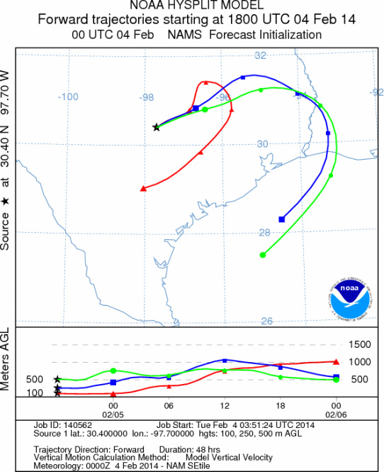
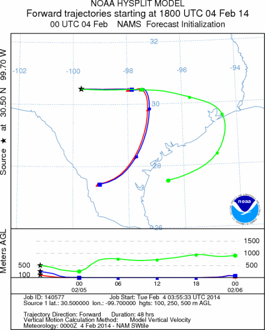
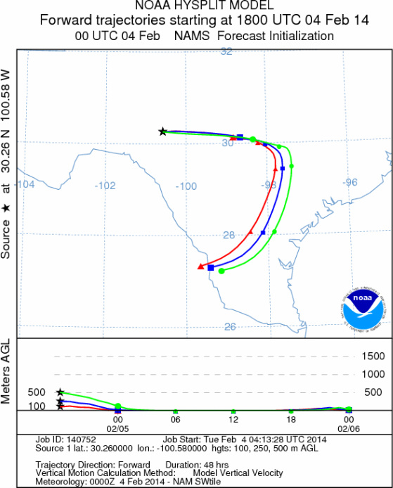
Trajectory weather: The air mass over central Texas will begin the day with partly to mostly cloudy conditions
and a westerly flow over the Plateau. Just to the east of the I-35 corridor rain showers have been moving on the
southwesterly flow. During the day the wind trajectories will be drawn into the more buoyant atmosphere and thee
is a good chance that the associated rain will wash any pollen out of the atmosphere. Overall conditions today
will be warm across the plateau with temperatures expected in the 60s and closing in on the 70s in the edge communities,
Across the area this morning patchy fog may remain from the overnight hours and the edge communities will begin
the day with a 20% to 30% chance of rain in the morning. Winds will maintain themselves from the west during the
day. Tonight cold conditions build back in as the winds switch coming from the north at light levels. Tomorrow
partly cloudy skies will begin the day but will break-up with a partly to mostly sunny afternoon. However, the
cold conditions will remain with high temperatures constricted to the upper 40s and low 50s. The Edwards Plateau
will remain in the low 40s and upper 30s. Winds will build to moderately strong conditions and remain from the
north continuing to bring cold winds southward. Tomorrow night the region will drop well below freezing with only
the southernmost communities avoiding the 20 degree range. Over the forecast period the atmosphere will be cold
and dense mostly moving at or near the ground surface. Today will be the one exception as winds push the atmosphere
towards the rains currently in eastern Texas they will become buoyant and lift into the weather system, however
rainfall associated with the system should wash suspended particles out of the air mass.
OUTLOOK: *** Moderate Threat Today and Moderate Threat Tomorrow *** Conditions
for pollen release today will be marginal with warm conditions and temperatures mostly in the upper 60s. Winds
will be from the west at light to moderate conditions initially building to stronger conditions this afternoon.
A weather system to the east is drawing the trajectories towards it. There currently is a lot of moisture in
the area and the radar indicates showers that would remove entrained particles. During the day the skies will
begin and continue to clear as cold northerly air moves into the region. Tonight lows will be in the 20s to 30s,
then tomorrow highs will be restricted to the 30s and 40s on the Plateau. The edge communities will build into
the mid-50s in the warmest areas. In general a mix of weather that will have elements today that will be conducive
for pollination, although the winds should stay close to the ground. Then cold air moves in and tomorrow, conditions
will be good but close to marginal for release. Overall the conditions will be marginal but in sheltered areas
where warming can occur there should be patches of high to severe levels. The overall trend of pollen counts seems
to be waning. The current forecast presents a mix of weather conditions and that will continue into the foreseeable
future. As we look back traditionally we are getting close to the end of the season We continue to test the
overall progress of the pollination season as it nears its end.
Trajectory Start (s) (shown by *
on map): Austin, TX; Junction, TX; Sonora, TX.
AUSTIN
JUNCTION
SONORA
EDWARDS PLATEAU COMPOSITE
Prepared by: Estelle
Levetin (Faculty of Biological
Science, The
University of Tulsa, 800 S. Tucker Dr., Tulsa, OK 74104) and ) and Peter
K Van de Water (Department of Earth and Environmental Science, California State University Fresno,
2576 East San Ramon Avenue, M/S ST24, Fresno CA 93740-8039). This forecast gives the anticipated future track of
released Mountain Cedar pollen, weather conditions over the region and along the forecast pathway, and an estimated
time of arrival for various metropolitan areas.
Questions: Aerobiology Lab e-mail: pollen@utulsa.edu
Return to Forecasting Home Page