
The University of Tulsa
Mountain Cedar Pollen Forecast
Metropolitan Area |
Exposure Risk |
|
Dallas/Fort Worth |
Low |
|
Austin |
Low |
|
San Antonio |
Moderate |
Date Issued: 5 February 2014
Mountain Cedar Location(s): Edwards Plateau, Texas
Regional Weather: Wednesday, February 5 TX/OK:.
The region will begin today with mostly cloudy skies and very cold conditions to the north and seasonal conditions
across the Edwards Plateau. In Oklahoma high temperatures today will only be in the upper teens and low 20s.
The overall flow will be from the north and cold air will dominate the northern areas as well as across Texas over
the forecast period. Today the Edwards Plateau will have mostly cloudy skies with temperatures reaching into the
low 40s to the east and mid to low 30s to the west. Overnight temperatures will fall into the low 20s and teens.
Winds will be from the northeast at light to moderate conditions. In the edge communities temperatures today
will struggle to get to the upper 40s and mid-50s to the south. Early partly-cloudy skies will give way during
the day to mostly sunny conditions. Winds will also be from the northeast at moderate levels. Across the northern
area, including the Dallas/Ft. Worth metro region temperatures will be in the mid-30s to upper 20s near the Texas/Oklahoma
border. Overnight cold conditions will bring low temperatures across the Edwards Plateau to the low 20s and upper
teens. The edge communities will be in the mid-20s and to the north drop into the teens with Oklahoma bottoming
out in the single digits. Winds across the region will be moderate and from the northeast. Tomorrow cloudy skies
will dominate with a building chance of snow across Oklahoma and the border area with Texas. The remainder of
the Texas high temperatures will be in the 30s. There will be a chance of freezing drizzle in the edge communities.
Winds will remain cold and at light to moderate conditions from the northeast. Tomorrow night the same conditions
will remain with cloudy to mostly cloudy conditions, temperatures across the region in the 20s across Texas and
low teens to single digits in Oklahoma. Winds will continue in most areas from the northeast at light to moderate
conditions.
Trajectory weather: The air mass over central Texas will begin the day with mostly cloudy conditions and
a northeasterly flow as very cold air covers the region. Conditions over the forecast period will be cold with
high temperatures today struggling into the high 40s to mid-50s in the southern most areas. The rest of the region
will remain in the mid-40s to mid-30s. Winds will be moderately strong from the northeast. Overall conditions
for pollen release will be marginal but to the south conditions will be within the temperature range for release.
The dominant northeasterly winds should carry any pollen entrained towards the southwest. The air will be dense
and cold thus the trajectories will travel at or near ground level. Tomorrow temperatures will fall even further,
with most of the forecast area not getting above the 30 degree mark. There will be a chance of frozen drizzle
and/or non-frozen drizzle in the edge communities and along the I-35 corridor. If it falls as frozen drizzle,
hazardous driving conditions may build across the region. Winds will remain from the northeast at moderate to
light levels. Tomorrow night lows will be in the 20s across the region. On the Edwards Plateau winds will be
from the east and far to the west a change will occur with a more southeasterly flow. Pollen release today and
tomorrow will be restricted by the overall cold conditions, cloudy skies and greater amounts of humidity in the
air. If pollen is released conditions are not particularly good for entrainment and travel will be mostly near
ground level because of the dense cold atmosphere. Conditions today will deteriorate towards tomorrow with colder
conditions.
OUTLOOK: *** Low to Moderate Threat
Today and Low Threat Tomorrow *** Conditions for pollen release today will be marginal with temperatures
mostly falling in the mid-to upper 40s and low 50s in the best areas. The Edwards Plateau is expected to only
be in the 30s and low 40s. Winds will be from the northeast at moderate conditions. Tonight lows will be in the
teens and 20s, then tomorrow highs will be restricted to the 30s region wide. There will be poor conditions for
pollen release across the region tomorrow. In general a mix of weather will remain across the region with cold,
cloudy conditions and winds from the northeast. There will be a chance of drizzle both frozen and non-frozen in
the edge communities and along the I-35 corridor. On top of the marginal conditions, the overall trend of pollen
counts seems to be waning. The current forecast presents a mix of weather conditions and that will continue into
the foreseeable future. As we look back traditionally we are getting close to the end of the season We continue
to test the overall progress of the pollination season as it nears its end.
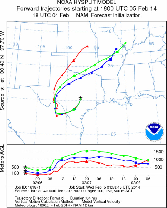
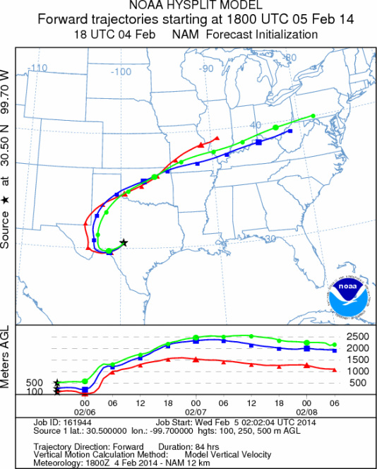
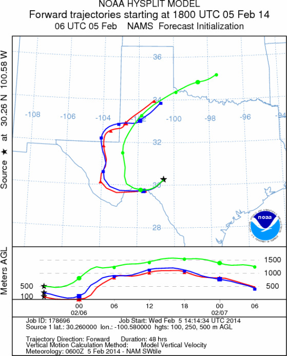
Trajectory Start (s) (shown by *
on map): Austin, TX; Junction, TX; Sonora, TX.
AUSTIN
JUNCTION
SONORA
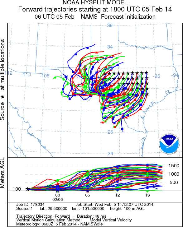
EDWARDS PLATEAU COMPOSITE
Prepared by: Estelle
Levetin (Faculty of Biological
Science, The
University of Tulsa, 800 S. Tucker Dr., Tulsa, OK 74104) and ) and Peter
K Van de Water (Department of Earth and Environmental Science, California State University Fresno,
2576 East San Ramon Avenue, M/S ST24, Fresno CA 93740-8039). This forecast gives the anticipated future track of
released Mountain Cedar pollen, weather conditions over the region and along the forecast pathway, and an estimated
time of arrival for various metropolitan areas.
Questions: Aerobiology Lab e-mail: pollen@utulsa.edu
Return to Forecasting Home Page