
The University of Tulsa
Mountain Cedar Pollen Forecast
Metropolitan Area |
Exposure Risk |
|
Dallas/Fort Worth |
Low |
|
Austin |
Low |
|
San Antonio |
Low |
Date Issued: 6 February 2014
Mountain Cedar Location(s): Edwards Plateau, Texas
Regional Weather: Thursday, February 6 TX/OK:.
The region will begin today with cloudy skies and very cold conditions across the region. Overnight temperatures
were below freezing and cold conditions will remain in place during the forecast period. From Oklahoma City south
down the I-35 corridor, precipitation is likely in the form of snow to the north and freezing drizzle to the south.
There is a 70% chance of snow in Oklahoma, 50% chance in Dallas, and freezing drizzle south to San Antonio. Temperatures
today will remain in the teens to low twenties in Oklahoma. In Texas the Edwards Plateau will only reach the upper
20s and low 30s today. The edge communities will remain mostly in the 30s with San Antonio forecast to only touch
the 40 degree mark. Winds will be from the north and northeast blowing across the region to the southwest. Tonight
temperatures will be in the low teens and single digits north, and across Texas the Plateau will drop into the
teens. The edge communities will be in the upper 20s to 30 degrees. Winds will remain from the north and northeast
but become light in most areas. Tomorrow there will be a 50% chance of snow across the north decreasing to the
south but the Dallas/Fort Worth area will have a 20% chance in the morning. The return of frozen drizzle will
once again be a possibility south along the I-35 corridor to San Antonio. High temperatures across Texas tomorrow
will warm into the mid-40s in most areas. Across the Edwards Plateau winds will begin to shift to a more southerly
flow. Tomorrow night the skies will begin to break up with partly cloudy conditions. Low temperatures will be
in the upper 20s to low 30s overnight on the Edwards Plateau. To the north Oklahoma will see snow once again but
with warmer low temperatures than have been seen in the last couple of days. Winds will be shifting, coming from
the south and southwest.
Trajectory weather: The air mass over central Texas will begin the day with cloudy conditions and a northeasterly
flow as very cold air covers the region. Conditions over the forecast period will be cold with high temperatures
today struggling to reach 40 degrees in the warmest areas. The rest of the region will remain in the upper 20s
to mid-30s. Winds will be moderately strong from the northeast. Overall conditions for pollen release will be
poor for release. The dominant northeasterly winds will move the atmosphere towards the southwest. The overall
wind pattern will then turn as the winds move northward again. This is reflected in the trajectories. Tomorrow
temperatures will climb with most areas in the low 40s. With the very cold conditions today it is thought that
the trees will struggle to get any pollen release with the poor overall conditions. Winds will remain from the
northeast to the north and among the edge communities. On the western Plateau the winds will be changing, coming
from the south and southeast. Tomorrow night lows will return to the 20s in the north and on the Edwards Plateau.
In the edge communities lows will remain in the mid- to low 30s.
OUTLOOK: *** Low Threat Today and Low Threat Tomorrow *** Conditions for pollen
release today will be poor with temperatures in the upper 20s to mid-30s for the highs. Winds will be from the
northeast at moderate conditions. Tonight lows will be in the teens and low 20s, then tomorrow highs will warm
a bit but only reach the mid- to upper 40s as the high temperature. Winds will be light in most areas. There
will be poor conditions for pollen release across the region again tomorrow. In general a mix of weather will
remain across the area with cold, cloudy conditions and winds from the northeast initially but by tomorrow afternoon
winds will switch coming from the south to the west. There will be a chance of drizzle both frozen and non-frozen
in the edge communities and along the I-35 corridor north towards Dallas. On top of the marginal conditions, the
overall trend of pollen counts seems to be waning. The current forecast presents a mix of weather conditions and
that will continue into the foreseeable future. As we look back traditionally we are getting close to the end
of the season We continue to test the overall progress of the pollination season as it nears its end.
Trajectory Start (s) (shown by *
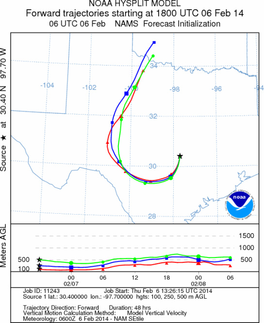
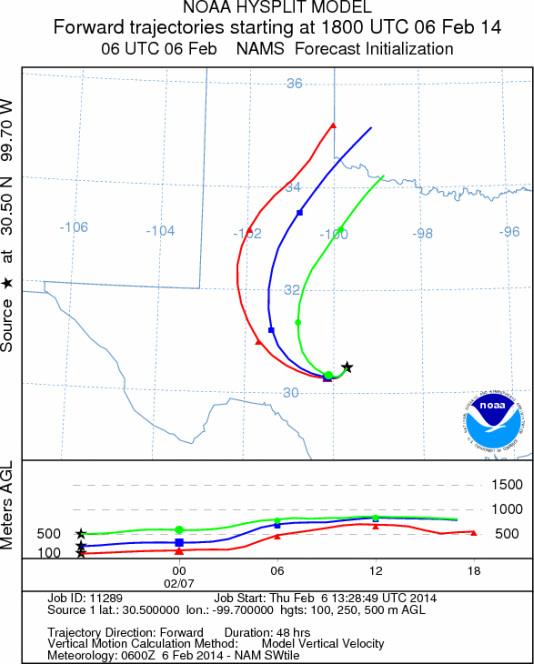
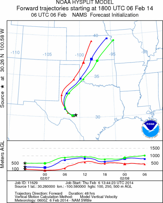
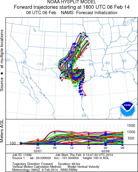
on map): Austin, TX; Junction, TX; Sonora, TX.
AUSTIN
JUNCTION
SONORA
EDWARDS PLATEAU COMPOSITE
Prepared by: Estelle
Levetin (Faculty of Biological
Science, The
University of Tulsa, 800 S. Tucker Dr., Tulsa, OK 74104) and ) and Peter
K Van de Water (Department of Earth and Environmental Science, California State University Fresno,
2576 East San Ramon Avenue, M/S ST24, Fresno CA 93740-8039). This forecast gives the anticipated future track of
released Mountain Cedar pollen, weather conditions over the region and along the forecast pathway, and an estimated
time of arrival for various metropolitan areas.
Questions: Aerobiology Lab e-mail: pollen@utulsa.edu
Return to Forecasting Home Page