The University of Tulsa
Mountain Cedar Pollen Forecast

Metropolitan Area |
Exposure Risk |
|
Oklahoma City |
Low |
|
Tulsa |
Low |
|
St. Louis MO |
Low |
Date Issued: 7 February 2014
Mountain Cedar Location(s): Arbuckle Mountains, OK
Regional Weather: Friday, February 7 – TX/OK:.
The region will begin today with mostly cloudy to cloudy skies and cold
conditions across the region. Overnight temperatures were below
freezing and cold conditions will remain in place today and then show a
slight warm up tomorrow. From Oklahoma City south down the I-35
corridor, precipitation is likely in the form of freezing drizzle and
sleet this morning turning to drizzle and rain this afternoon. High
Temperatures will climb into the mid to upper 40s on the Edwards Plateau
but remain in the upper 30s in the edge communities from San Antonio to
the Dallas/Ft. Worth metro region. Across the area there is a 20% to
30% chance of precipitation in any one location. The edge communities
will remain under a northeast flow of cold air, whereas the Edwards
Plateau will see the overall flow coming from the south at slightly
stronger conditions. Tonight the Edwards Plateau will be mostly clear
with temperatures below freezing and the western portion into the upper
20s. In the edge communities temperatures will remain above freezing
but be in the 30s. In Oklahoma overnight mostly clear skies and very
cold conditions will remain. Lows will be in the upper teens and low
20s. Tomorrow warming will begin across the Edwards Plateau and in the
edge communities with highs expected to reach the mid to upper 60s. The
warm conditions will reach the Dallas/Fort Worth area with upper 50s
expected in the afternoon. In Oklahoma, it will be warmer than it has
been lately, the upper 40s are expected near the border and further
north conditions will remain in the 30s. Across the Edwards Plateau
winds will be light to moderate from the west. In the edge communities a
more southwesterly flow will occur at light levels, and to the north
winds will be from the west and southwest at light levels as well.
Overnight tomorrow, partly cloudy conditions will dominate across Texas
with lows remaining above freezing. The Plateau will drop into the
mid-30s while the edge communities and areas in the I-35 corridor will
remain in the 40s. Winds will be from the southwest at light to
moderate levels. Northward in the border area with Oklahoma stretching
northward cold conditions will remain with lows in the 20s.
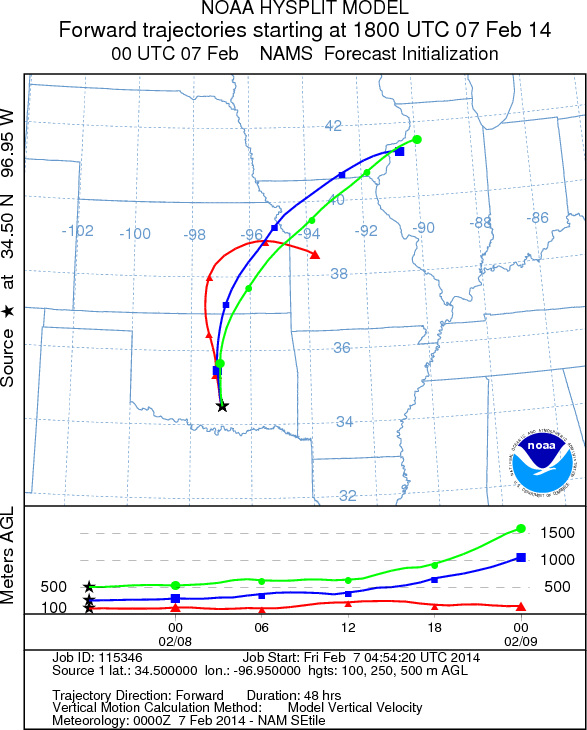
Trajectory weather:
The trajectories over the Arbuckles shows the air mass moving north
over central Oklahoma and into Kansas. Conditions over the forecast
period will be cold with high temperatures today in the mid to upper 20s
degrees in the warmest areas. Winds will be light to moderate from the
south, southeast with a chance of light snow. Overall conditions for
pollen release will be poor for release. Tomorrow temperatures will
climb with most areas in the mid to upper 20s and low 30s. The
conditions will once again be very poor for pollination. Tomorrow night
lows will return to the teens and low 20s.
OUTLOOK: *** Low Threat Today and Low Threat Tomorrow ***
Conditions for pollen release today will be poor with temperatures in
the lower to mid 20s for the highs. There will be poor conditions for
pollen release across the area again tomorrow. On top of the marginal
conditions, the overall trend of pollen counts seems to be waning. The
current forecast presents a mix of weather conditions and that will
continue into the foreseeable future. As we look back traditionally we
are getting close to the end of the season We continue to test the
overall progress of the pollination season as it nears its end.
Trajectory Start (s) (shown by black star on map): Davis, OK.
Prepared by: Estelle Levetin (Faculty of Biological Science, The University of Tulsa, 800 S. Tucker Dr., Tulsa, OK 74104) and Peter K Van de Water (Department of Earth and Environmental Science, California State University Fresno, 2576 East San Ramon Avenue, M/S ST24, Fresno CA 93740-8039). This forecast gives the anticipated future track of released Mountain Cedar pollen, weather conditions over the region and along the forecast pathway, and an estimated time of arrival for various metropolitan areas.
Questions: Aerobiology Lab e-mail: pollen@utulsa.edu
Return to Forecasting Home Page