
The University of Tulsa
Mountain Cedar Pollen Forecast
Metropolitan Area |
Exposure Risk |
|
Dallas/Fort Worth |
Low |
|
Austin |
Moderate |
|
San Antonio |
Moderate |
Date Issued: 7 February 2014
Mountain Cedar Location(s): Edwards Plateau, Texas
Regional Weather:
Friday, February 7 – TX/OK:. The region will begin today with mostly cloudy
to cloudy skies and cold conditions across the region. Overnight temperatures were below freezing
and cold conditions will remain in place today and then show a slight warm up
tomorrow. From Oklahoma City south down
the I-35 corridor, precipitation is likely in the form of freezing drizzle and
sleet this morning turning to drizzle and rain this afternoon. High Temperatures will climb into the mid to
upper 40s on the Edwards Plateau but remain in the upper 30s in the edge
communities from San Antonio to the Dallas/Ft. Worth metro region. Across the area there is a 20% to 30% chance
of precipitation in any one location.
The edge communities will remain under a northeast flow of cold air,
whereas the Edwards Plateau will see the overall flow coming from the south at
slightly stronger conditions. Tonight
the Edwards Plateau will be mostly clear with temperatures below freezing and
the western portion into the upper 20s.
In the edge communities temperatures will remain above freezing but be
in the 30s. In Oklahoma overnight mostly
clear skies and very cold conditions will remain. Lows will be in the upper teens and low
20s. Tomorrow warming will begin across
the Edwards Plateau and in the edge communities with highs expected to reach
the mid to upper 60s. The warm
conditions will reach the Dallas/Fort Worth area with upper 50s expected in the
afternoon. In Oklahoma, it will be
warmer than it has been lately, the upper 40s are expected near the border and
further north conditions will remain in the 30s. Across the Edwards Plateau winds will be
light to moderate from the west. In the
edge communities a more southwesterly flow will occur at light levels, and to
the north winds will be from the west and southwest at light levels as well. Overnight tomorrow, partly cloudy conditions
will dominate across Texas with lows remaining above freezing. The Plateau will drop into the mid-30s while
the edge communities and areas in the I-35 corridor will remain in the
40s. Winds will be from the southwest at
light to moderate levels. Northward in
the border area with Oklahoma stretching northward cold conditions will remain
with lows in the 20s.
Trajectory weather: The air mass over central Texas will begin the day with cloudy
conditions and the chance of precipitation region wide. In areas that awaken to freezing temperatures
have the potential of freezing drizzle and sleet. If buildup has occurred dangerous driving
conditions will exist. Today as the air
warms the frozen precipitation will melt and there will be a continuous chance
of drizzle during the warming portion of the day. Winds across the Edwards Plateau will be
light to moderate from the south, whereas areas along the edge of the Plateau and
north into the Dallas/Ft. Worth metro region will remain from the cold
northeast. Tonight the Plateau will
become mostly clear and temperatures will drop below freezing into the low 30s
and upper 20s. Winds will be light to
moderate from the southwest. In the edge
communities mostly cloudy skies will occur with temperatures above freezing to
the south but below freezing northwards towards Waco and the Dallas/ Ft. Worth
area. Winds will be from the southeast
initially moving towards a more southerly direction overnight. Tomorrow warming will occur with most areas
in central Texas building into the upper 60s.
Winds will be stronger on the Plateau, at moderate levels, with an
overall flow from the west. In the edge
communities the winds will remain light and from the southwest. Cloudy conditions along the I-35 corridor
will become mostly sunny during the day, whereas mostly sunny skies over the
Plateau region will become partly cloudy.
Tomorrow night the partly cloudy skies will prevail across the region. Low temperatures will be in the mid-30s on
the plateau and in the mid to lower 40s in the surrounding communities. The southwesterly flow will dominate at light
levels.
OUTLOOK: *** Low Threat Today and Moderate Threat Tomorrow *** Conditions for pollen release today will be poor with
temperatures in the 30s to low-40s for the highs. All areas will have the chance at frozen
precipitation this morning then moist and humid conditions during the rest of
the day. Winds will be from the south
over the Plateau and from the northeast at moderate conditions elsewhere. Tonight lows will be in the low thirties to
upper 20s under mostly cloudy to cloudy conditions. Tomorrow highs will warm
into the 60s across Texas. Winds will be
from the west at moderate conditions across the Plateau and from the southwest
in the edge communities at lighter levels.
Tomorrow night the Plateau will be just at the freezing mark whereas the
rest of the region will be above freezing.
In general a mix of weather will be across the area with cold, cloudy
conditions and the chance of precipitation throughout the day. These are generally moderate to poor
conditions for pollen release, however we are nearing the traditional end of
the pollination season so we expect low levels to occur if where pollen is
still being release. Tomorrow will be
the real test as warm conditions will be across the area with the densest
population of trees. We have seen
indications of a significant relaxation of pollen in the atmosphere during the
last week of very marginal weather conditions.
Overall we see that the overall pollen counts seem
to be waning. The current forecast
presents a mix of weather conditions and that will continue into the
foreseeable future. As we look back traditionally
we are getting close to the end of the season. We continue to test the overall progress of
the pollination season as it nears its end.
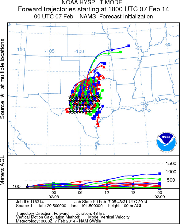
Trajectory Start (s) (shown by *
on map): Austin, TX; Junction, TX; Sonora, TX.
AUSTIN
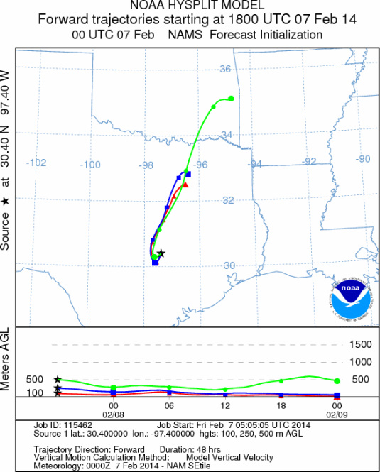
JUNCTION
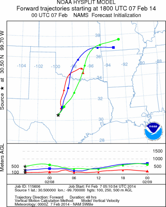
SONORA
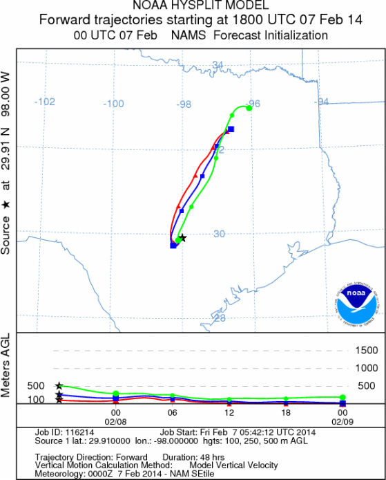
EDWARDS PLATEAU COMPOSITE
Prepared by: Estelle
Levetin (Faculty of Biological
Science, The
University of Tulsa, 800 S. Tucker Dr., Tulsa, OK 74104) and ) and Peter
K Van de Water (Department of Earth and Environmental Science, California State University Fresno,
2576 East San Ramon Avenue, M/S ST24, Fresno CA 93740-8039). This forecast gives the anticipated future track of
released Mountain Cedar pollen, weather conditions over the region and along the forecast pathway, and an estimated
time of arrival for various metropolitan areas.
Questions: Aerobiology Lab e-mail: pollen@utulsa.edu
Return to Forecasting Home Page