The University of Tulsa
Mountain Cedar Pollen Forecast

Metropolitan Area |
Exposure Risk |
|
Oklahoma City |
Low |
|
Tulsa |
Low |
|
St. Louis MO |
Low |
Date Issued: 8 February 2014
Mountain Cedar Location(s): Arbuckle Mountains, OK
Regional Weather:
Saturday/Sunday, February 8/9 – TX/OK:. Warm
weather will return to the Texas region
today with partly to mostly cloudy skies this morning burning off to
mostly
sunny and clear skies this afternoon.
Along the I-35 corridor foggy conditions will occur this morning . To
the north in Oklahoma partly cloudy skies
but with the chance of freezing fog will occur today as the sun rises.
Highs in Oklahoma today will be in the 30s to
the north and low to mid 40s in the border region. Winds will be light
from the south. Across Texas warmer temperatures will build
in on southerly winds. Highs today will
be in 60s to low 70s across the Edwards Plateau and in the 60s in the
edge
communities. Winds will be from the
south to southwest at light conditions.
On the Plateau, later in the day winds will become stronger. Tonight
mostly clear conditions will prevail
across Texas. Low temperatures will be
seasonal dropping into the 30s and 40s but staying above the freezing
level. Winds will remain from the south
and southwest at light to moderate conditions.
In Oklahoma mostly clear to partly cloudy skies will allow temperatures
to once again drop into the 20s but winds will be light and variable.
Tomorrow, Oklahoma will have partly to mostly
cloudy skies and temperatures will remain in the 30s to low 40s. Winds
will have switched, coming from the
northeast which will be a signal for similar changes eventually
occurring
across Texas. Tomorrow in Texas mostly
sunny conditions and warm temperatures will be in order. Most areas
will reach into the mid-70s. Winds will be from the southwest at light
to
moderate conditions. Tomorrow night the
skies will become partly cloudy then mostly cloudy after midnight.
Temperatures will drop with the Plateau and
north portions of Texas back in the low 30’s and the edge communities
dropping
into the low 40s. Winds that had been
from the south and southwest will change coming out of the northeast at
moderate levels bringing cold air for another cool down. Across
Oklahoma there will be a 20% chance of
snow in Oklahoma City and lows will be back in the upper teens to low
20s.
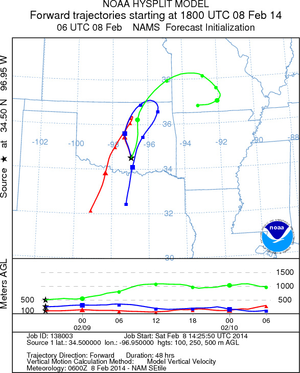
Trajectory weather:
The air mass over the Arbuckle Mountains will move to the north
and northeast during the day today. Overnight the shift in winds
and cold air
will move in over the area. The
trajectories today will be near the surface and light wind conditions
will mean
that they do not travel very far. As the
next push of cold air occurs it will slide in under the current air
mass and
thus tomorrow many of the trajectories will begin to move up in the
atmosphere. The overall light wind
strengths suggest that the trajectories will not move far over the
forecast
period.
OUTLOOK: *** Low Threat Today and Low Threat Tomorrow
*** Conditions
for pollen release across southern Oklahoma are poor with forecast
highs in the upper 30s to low 40s today and even colder tomorrow. As
we look back, we are getting close to the traditional end of the season. We continue to test the overall progress of
the pollination season as it nears its end.
Trajectory Start (s) (shown by black
star on map): Davis, OK.
Prepared by: Estelle
Levetin
(Faculty
of Biological Science, The University of Tulsa, 800 S. Tucker Dr., Tulsa, OK 74104) and Peter
K Van de Water
(Department of Earth and Environmental Science, California State University Fresno, 2576 East San Ramon Avenue,
M/S ST24, Fresno CA 93740-8039). This forecast gives the anticipated future track of released Mountain Cedar pollen,
weather conditions over the region and along the forecast pathway, and an estimated time of arrival for various
metropolitan areas.
Questions: Aerobiology Lab e-mail: pollen@utulsa.edu
Return to Forecasting Home Page