
The University of Tulsa
Mountain Cedar Pollen Forecast
Metropolitan Area |
Exposure Risk |
|
Dallas/Fort Worth |
Moderate |
|
Austin |
Moderate |
|
San Antonio |
Moderate |
Date Issued: 8 February 2014
Mountain Cedar Location(s): Edwards Plateau, Texas
Regional Weather: Saturday/Sunday, February 8/9 – TX/OK:.
Warm weather will return to the Texas region
today with partly to mostly cloudy skies this morning burning off to
mostly
sunny and clear skies this afternoon.
Along the I-35 corridor foggy conditions will occur this morning . To
the north in Oklahoma partly cloudy skies
but with the chance of freezing fog will occur today as the sun rises.
Highs in Oklahoma today will be in the 30s to
the north and low to mid 40s in the border region. Winds will be light
from the south. Across Texas warmer temperatures will build
in on southerly winds. Highs today will
be in 60s to low 70s across the Edwards Plateau and in the 60s in the
edge
communities. Winds will be from the
south to southwest at light conditions.
On the Plateau, later in the day winds will become stronger. Tonight
mostly clear conditions will prevail
across Texas. Low temperatures will be
seasonal dropping into the 30s and 40s but staying above the freezing
level. Winds will remain from the south
and southwest at light to moderate conditions.
In Oklahoma mostly clear to partly cloudy skies will allow temperatures
to once again drop into the 20s but winds will be light and variable.
Tomorrow, Oklahoma will have partly to mostly
cloudy skies and temperatures will remain in the 30s to low 40s. Winds
will have switched, coming from the
northeast which will be a signal for similar changes eventually
occurring
across Texas. Tomorrow in Texas mostly
sunny conditions and warm temperatures will be in order. Most areas
will reach into the mid-70s. Winds will be from the southwest at light
to
moderate conditions. Tomorrow night the
skies will become partly cloudy then mostly cloudy after midnight.
Temperatures will drop with the Plateau and
north portions of Texas back in the low 30’s and the edge communities
dropping
into the low 40s. Winds that had been
from the south and southwest will change coming out of the northeast at
moderate levels bringing cold air for another cool down. Across
Oklahoma there will be a 20% chance of
snow in Oklahoma City and lows will be back in the upper teens to low
20s.
Trajectory weather: The air mass over central Texas will begin the day with cloudy
and partly cloudy conditions and the chance of patchy fog across the edge
communities. With the southwesterly winds, at light to moderate conditions, the
region will warm significantly from last week with conditions expected to be in
the 70s in the central Edwards Plateau and 60s to the west and in the edge
communities. Overnight clear to mostly
clear skies will occur with lows in the 30s across the Plateau and in the low
40s in the edge communities. Northward
towards the Dallas/Ft. Worth region cooler conditions will prevail with the
metro region expected to be in the med-30s.
Winds will be from the southwest at light levels. Tomorrow mostly sunny skies will occur after
morning clouds burn off. Temperatures
are heading once again into the mid-70s across the central Texas region. Dallas/Ft. Worth will be in the mid 50’s and
northward towards the border with Oklahoma colder air will drop temperatures
into the lower 40s. Winds will be from
the southwest at moderate conditions across the Edwards Plateau and in the edge
communities. To the north, colder conditions
will occur along with the winds moving to a northeasterly direction. Overnight the shift in winds and cold air
will move in over the area. The
trajectories today will be near the surface and light wind conditions will mean
that they do not travel very far. As the
next push of cold air occurs it will slide in under the current air mass and
thus tomorrow many of the trajectories will begin to move up in the
atmosphere. The overall light wind
strengths suggest that the trajectories will not move far over the forecast
period.
OUTLOOK: *** Moderate Threat Today and Moderate Threat Tomorrow
*** Conditions
for pollen release across Texas today will be good with temperatures in
the 70s
and dry conditions. Winds will be light to moderate from
the southwest
over the region. Tonight lows will be in
the thirties with the southern edge communities staying near 40
degrees. Tomorrow highs will warm into the 70s across
Texas. Winds will be from the southwest
at moderate conditions across the Plateau.
Tomorrow night the Plateau will be in the mid-30s with the edge
communities
in the mid-40s. These conditions are
generally good for pollen release, however we are nearing the
traditional end
of the pollination season and have begun to see the tailing off of
pollen
levels so we expect low levels to occur where pollen is still being
released. Tomorrow will be the real test with very warm
conditions across the area with the densest population of trees.
Overall pollen counts
seem to be waning. The current forecast
presents really good conditions for pollen release and this will be a
test of
the amount of pollen left in the trees. As
we look back, we are getting close to the traditional end of the
season. We continue to test the overall progress of
the pollination season as it nears its end.
Trajectory Start (s) (shown by *
on map): Austin, TX; Junction, TX; Sonora, TX.
AUSTIN
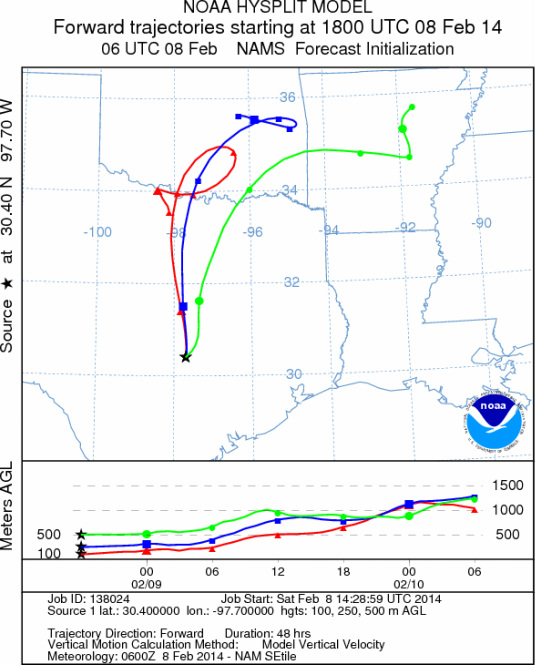
JUNCTION
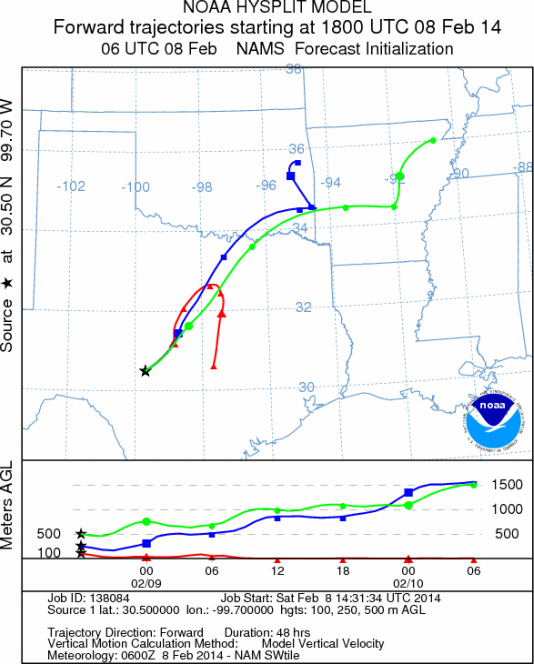
SONORA
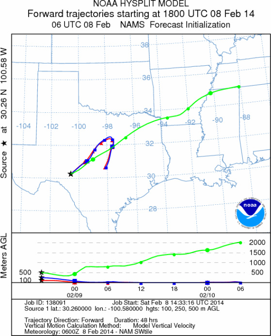
EDWARDS PLATEAU COMPOSITE
Not available
Prepared by: Estelle
Levetin (Faculty of Biological
Science, The
University of Tulsa, 800 S. Tucker Dr., Tulsa, OK 74104) and ) and Peter
K Van de Water (Department of Earth and Environmental Science, California State University Fresno,
2576 East San Ramon Avenue, M/S ST24, Fresno CA 93740-8039). This forecast gives the anticipated future track of
released Mountain Cedar pollen, weather conditions over the region and along the forecast pathway, and an estimated
time of arrival for various metropolitan areas.
Questions: Aerobiology Lab e-mail: pollen@utulsa.edu
Return to Forecasting Home Page