
The University of Tulsa
Mountain Cedar Pollen Forecast
Metropolitan Area |
Exposure Risk |
|
Dallas/Fort Worth |
Low |
|
Austin |
Low |
|
San Antonio |
Moderate |
Date Issued: 10 February 2014
Mountain Cedar Location(s): Edwards Plateau, Texas
Regional Weather: Monday, February 10 – TX/OK:. Cold weather will return to the Southern
Oklahoma and Texas region today with mostly cloudy and cloudy skies. Early this morning with low temperatures
there will be a chance of freezing drizzle across the Edwards Plateau and north
in the Dallas/Ft. Worth area extending into Oklahoma. In the Oklahoma City region there will be a
50% chance of snow. Lows to the north
will be in the mid-20s to 30 degrees.
Winds will be from the north at moderate to strong conditions. In Texas, temperatures will mostly be in the
30s to the north in the Dallas/Ft. Worth area, in the 40s across the Plateau
and in the Austin area, and just into the low 50s in San Antonio. The region will have a northeasterly flow at
moderate levels. The Plateau will have a
20% chance of freezing drizzle early turning to just drizzle during the
afternoon. Tonight cloudy skies will
prevail across Texas and mostly cloudy conditions in Oklahoma. In all areas the chance of freezing rain and
drizzle will occur from 20% across the Plateau increasing to 30% and 40% in the
edge communities. The Dallas/Ft. Worth
metro region will have a 20% chance of frozen precipitation. In Oklahoma there will be a 30% chance of
snow and sleet. Temperatures will be in
the 20s in all areas except for the edge communities where they will flirt with
the freezing mark in the 30s. Winds will
maintain their moderate speeds from the northeast. Tomorrow the chance of freezing rain will
increase. The Plateau will have a 30%
chance, whereas the edge communities will see a 50% chance of frozen and
non-frozen precipitation. To the north
and into Oklahoma it will grade from freezing rain in the Dallas/Ft. Worth area
to snow in Oklahoma. Winds will remain
from the north at moderate levels with greater wind speed in the edge
communities. Tomorrow night will be mostly
to partly cloudy. The chance of frozen
precipitation will remain in the edge communities and across the Edwards
Plateau. Lows will be in the 20s, except
for the edge communities where the low will drop into the low 30s.
Trajectory weather: The air mass over Texas will begin the day with cloudy and mostly
cloudy conditions and the chance of freezing drizzle on the Edwards Plateau. The temperatures will be mostly in the low
40s with only San Antonio eventually reaching into the low 50s. Winds will be moderate from the northeast.
Overnight the chance of freezing rain and sleet increases across the
region. Temperatures will remain in the
20s on the Edwards Plateau and in the mid-30s across the edge communities. Winds will remain from the northeast at
moderate to strong conditions. The
chance of precipitation will run from 20% across the Edwards Plateau and to the
north towards the Dallas/Ft Worth region. It will be 30% to 40% in the edge
communities. Tomorrow night conditions
will remain very similar with the chance of rain returning to all of the areas
except the far western Edwards Plateau region.
Lows will be in the low 30s in the edge communities and in the 20s in
the other regions. Overall, there will
be poor conditions for pollination occurring today and tomorrow. Very marginal conditions will exist today
with slightly warmer conditions but it is expected to be moist and cold with
drizzle. Tomorrow conditions deteriorate
even more with none of the sites getting out of the mid-40s. With the dominant northerly winds over the
forecast period anything in the atmosphere will move south. The cold air will favor dense air that moves
near the ground.
OUTLOOK: *** Low Threat Today and Low Threat Tomorrow *** Conditions for pollen release today will be
marginal with high temperatures just getting into the upper 40s in the most
southern areas of the tree population. Winds
will be moderate from the northeast.
Tonight lows will return to the mid- to upper 20s across the Edwards
Plateau and to the north. In the edge
communities lows will remain in the mid-30s.
The chance of frozen precipitation in the form of drizzle and sleet will
increase across the area. The wet
conditions will continue tomorrow with it being frozen early and then warming a
bit during the afternoon. High
temperatures tomorrow will be in the low 40s at the warmest locations. Winds will remain from the north at moderate
to strong conditions. Tomorrow night
temperatures will be either at or below the freezing mark with the continued
chance of freezing precipitation remaining on the Edwards Plateau and in the
surrounding communities. On top of the marginal conditions, the overall trend of the pollen
levels has been waning. The current
forecast presents a mix of weather conditions and that will continue into the
foreseeable future. As we look back
traditionally we are at the end of the pollination season.
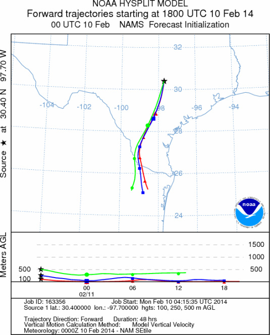
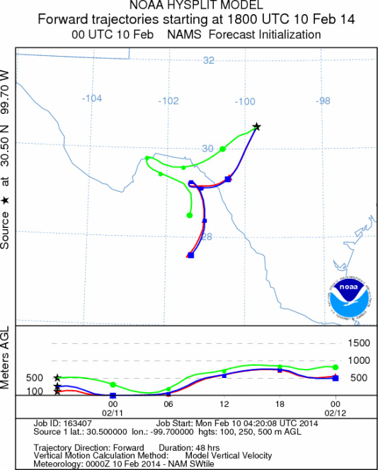
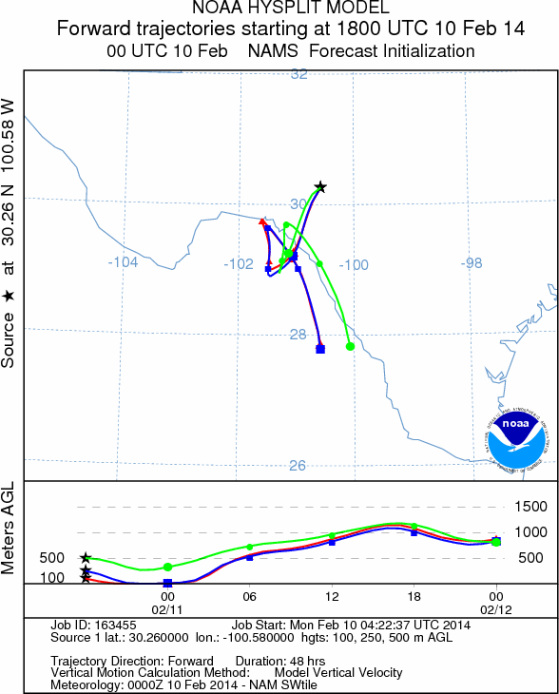
Trajectory Start (s) (shown by *
on map): Austin, TX; Junction, TX; Sonora, TX.
AUSTIN
JUNCTION
SONORA
EDWARDS PLATEAU COMPOSITE
Not available
Prepared by: Estelle
Levetin (Faculty of Biological
Science, The
University of Tulsa, 800 S. Tucker Dr., Tulsa, OK 74104) and ) and Peter
K Van de Water (Department of Earth and Environmental Science, California State University Fresno,
2576 East San Ramon Avenue, M/S ST24, Fresno CA 93740-8039). This forecast gives the anticipated future track of
released Mountain Cedar pollen, weather conditions over the region and along the forecast pathway, and an estimated
time of arrival for various metropolitan areas.
Questions: Aerobiology Lab e-mail: pollen@utulsa.edu
Return to Forecasting Home Page