
Date Issued: 12 January 1998
Mountain Cedar location(s): Edwards Plateau, Texas
Regional weather: Tuesday, January 12 - TX/OK: Dissipating cold front to the north.......developing low pressure area right over the region today. Mostly cloudy OK....partly to mostly cloudy elsewhere.....warm today with highs in the 60's and 70's.....moderate to strong winds. Combined influence of high to the north and the low pressure moving to the east will force some colder air into the region tonight and Wednesday. Chance of light precipitation in some parts of OK and eastern TX tonight and Wednesday. Lows tonight 20's and 30's north and west.....40's and 50's south and east. Highs on Wednesday 30's and 40's OK.....50's and 60's TX.
Trajectory weather: Austin: Variably to mostly cloudy today, high in the mid-70's. Chance of drizzle this evening and showers after midnight, low in the mid-30's. Chance of rain/freezing rain on Wednesday, high in the low 30's. Junction/San Angelo: Variably cloudy today with a high in the low 70's. Mostly cloudy and cooler tonight, low in the low 40's. Mostly cloudy with a slight chance of showers on Wednesday, high in the mid-60's.
Trajectory confidence: High
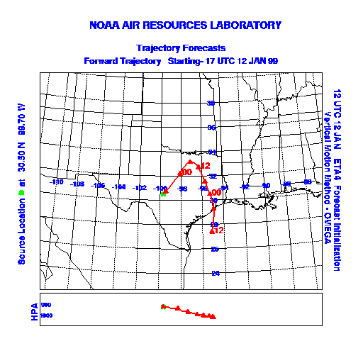
OUTLOOK: *** SERIOUS Threat *** Conditions remain favorable for pollen release today. Although humidities are still relatively high, temperature and wind conditions are quite favorable for pollen release. Significant release is expected. As happened yesterday, pollen released from the eastern end of the Plateau will get caught up in the flow ahead of the developing low, continuing north and east after this evening. Trajectories from the central and western sections of the Plateau will turn back to the south overnight as they encounter winds coming off the back side of the developing low. A large chunk of the Lone Star state will be loaded with airborne pollen through this evening....from the Edwards Plateau and south-central Texas northward towards the Oklahoma border. Some of the pollen will move across southeast Oklahoma and northern Arkansas overnight. Its potential impact on the populace will decrease during this time due to the expected precipitation. An even larger mass of airborne pollen will move through northern TX and then turn south overnight, approaching southeast Texas during the day on Wednesday. TK
Trajectory Start(s) (shown by green dot on map): Austin, TX; Junction, TX; San Angelo, TX
Austin, TX
Junction, TX
San Angelo, TX
Prepared by: Thomas Keever (Department of Marine, Earth and Atmospheric Sciences, NCSU), Estelle Levetin (Faculty of Biological Science, The University of Tulsa, 600 S. College, Tulsa, OK 74104), and C.E. Main (Department of Plant Pathology, North Carolina State University, Raleigh, NC 27695-7618). This forecast gives the anticipated future track of released Mountain Cedar pollen, weather conditions over the region and along the forecast pathway, and an estimated time of arrival for various metropolitan areas.
Questions: Aerobiology Lab e-mail: pollen@utulsa.edu
Return to Forecasting Home Page