|
Metropolitan Area |
Exposure Risk |
|
Dallas / Ft. Worth |
Low |
|
Austin |
Low |
|
San Antonio |
Low |
Mountain Cedar location(s): Edwards Plateau, Texas
Regional weather: Tuesday, January 16 - TX/OK/AR: Storm system in place over the region, fed by upper-atmospheric energy coming out of the U.S. Southwest. Clouds nearly everywhere with fog, drizzle, rain, or snow depending on your location. Bad weather will continue tonight and Wednesday. Highs today mostly 30's to 50's, lows tonight mostly 20's to 40's.
Trajectory weather: Cloudy with light rain likely, high in the 50's. Rain or snow likely tonight, low in the 10's panhandle to 20's western areas of north TX. Cloudy with a chance of snow Wednesday, high in the low 30's.
Trajectory confidence: High.
OUTLOOK: *** Low Threat *** Very unfavorable conditions for pollen release. Temperatures will move into the favorable range, but not far, this afternoon. Moisture conditions are highly unfavorable, however, with fog/drizzle/rain across the Plateau. No release expected, with Low Risk of exposure. TK
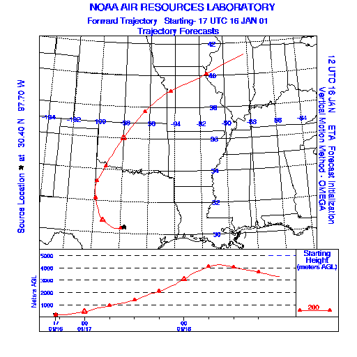
Trajectory Start(s) (shown by * on map): Austin, TX; Junction, TX; San Angelo, TX
Austin, TX
Junction, TX
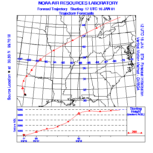
San Angelo, TX

Prepared by: Thomas Keever (Department of Marine, Earth and Atmospheric Sciences, NCSU), Estelle Levetin (Faculty of Biological Science, The University of Tulsa, 600 S. College, Tulsa, OK 74104), and C.E. Main (Department of Plant Pathology, North Carolina State University, Raleigh, NC 27695-7618). This forecast gives the anticipated future track of released Mountain Cedar pollen, weather conditions over the region and along the forecast pathway, and an estimated time of arrival for various metropolitan areas.
Questions: Aerobiology Lab e-mail: pollen@utulsa.edu
Return to Forecasting Home Page